IMAGES TAKEN NEAR TO
South Kinson Drive, BOURNEMOUTH, BH11 8AD
Introduction
This page details the photographs taken nearby to South Kinson Drive, BH11 8AD by members of the Geograph project.
The Geograph project started in 2005 with the aim of publishing, organising and preserving representative images for every square kilometre of Great Britain, Ireland and the Isle of Man.

There are currently over 7.5m images from over14,400 individuals and you can help contribute to the project by visiting https://www.geograph.org.uk
Image Map
Images are licensed for reuse under creativecommons.org/licenses/by-sa/2.0
Notes
- Clicking on the map will re-center to the selected point.
- The higher the marker number, the further away the image location is from the centre of the postcode.
Image Listing (52 Images Found)
Images are licensed for reuse under creativecommons.org/licenses/by-sa/2.0
Image
Details
Distance
1
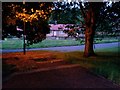
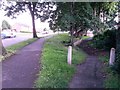
West Howe: a dusk view down footpath E09
The opposing view to Image], we look down the steps forming the public footpath leading from West Howe Close to Paget Road. The dead end of the former is immediately behind us, while the dead end of the latter is a short distance to the left and provides pedestrian access onto Kinson Common.
See Image] for a view behind us.
Image: © Chris Downer
Taken: 27 Jun 2016
0.04 miles
2
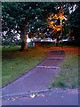
West Howe: footpath E09 to West Howe Close
Looking up the steps on this short public footpath from Paget Road, just as dusk starts to fall. See Image for a view down here from the top.
Image: © Chris Downer
Taken: 27 Jun 2016
0.04 miles
3
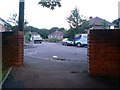
West Howe: footpath E09 emerges onto West Howe Close
A short public footpath comes up steps from Paget Road and emerges here at the dead end of West Howe Close.
See Image] for the view behind us from the wall on the right.
Image: © Chris Downer
Taken: 27 Jun 2016
0.05 miles
4

West Howe: Mount Road
When the large 1950s West Howe council estate was built, Mount Road utilised an original farm track or lane: overlaying older with present-day maps, the course is very obvious.
The sign is an early version of a standard Bournemouth design from around 2000, the early version recognisable by a slightly more emboldened typeface, aligned to the left when on two lines or, never on the newer versions, written on a single line as here.
This is photo no.286 of a series of 453 in my coronavirus lockdown walking project:
See Link for the complete set of photos.
Image: © Chris Downer
Taken: 18 Apr 2020
0.08 miles
5

West Howe: postbox № BH11 67, Rochester Road
This small postbox is on the corner of Rochester and Ritchie Roads. The surrounding semi-detached houses are typical of this large council estate.
Image: © Chris Downer
Taken: 17 Aug 2008
0.09 miles
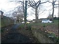
6
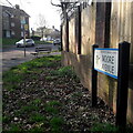
West Howe: Moore Avenue
Seen here ascending from Poole Lane, Moore Avenue is one of the chief roads into the large, 1950s West Howe council estate, as attested by the bus stop (there is a more substantial one opposite, out of picture, with bus shelter).
After the block of flats, more standard semi-detached council houses take over before more flats are found nearer the centre of the estate.
The road sign is a standard one from around 2000-2006, perhaps a little earlier, featuring the borough coat of arms.
This is photo no.279 of a series of 453 in my coronavirus lockdown walking project:
See https://www.geograph.org.uk/article/My-2020-Coronavirus-Lockdown-walking-project for the complete set of photos.
Image: © Chris Downer
Taken: 11 Apr 2020
0.12 miles
7
West Howe: footpath U29 leaves Moore Avenue
Moore Avenue continues up the hill, left, while this public footpath heads right. See Image] for the view towards us from the path ahead, and links to further photos on the path.
Image: © Chris Downer
Taken: 28 Jun 2016
0.12 miles
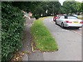
8
West Howe: footpath U29 reaches Moore Avenue
This short public footpath comes from the dead end of April Close and comes out ahead on Moore Avenue, which swings round uphill to head behind us to our right.
See Image for the view towards us from the pavement ahead, and Image for the next view on the path behind us.
Image: © Chris Downer
Taken: 6 Mar 2017
0.12 miles
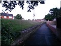
9
West Howe: footpath U28 diverges from Moore Avenue
Looking along Moore Avenue as it approaches Poole Lane (distance). The pedestrian who wishes to turn left at the bottom can cut the corner off via this public footpath which takes a much more direct route. See Image for a view up the path towards us, and links to further pictures on the way down.
Image: © Chris Downer
Taken: 30 Jun 2016
0.12 miles
10
West Howe: footpath U28 heads for Moore Avenue
This public footpath ascends to meet Moore Avenue almost parallel with it - it runs just to our left, at the top of the grass bank. See Image
See Image] for a view down onto the path behind us from the top of the grass bank to the left.
Image: © Chris Downer
Taken: 28 Jun 2016
0.12 miles