IMAGES TAKEN NEAR TO
Pearson Gardens, BOURNEMOUTH, BH10 7HZ
Introduction
This page details the photographs taken nearby to Pearson Gardens, BH10 7HZ by members of the Geograph project.
The Geograph project started in 2005 with the aim of publishing, organising and preserving representative images for every square kilometre of Great Britain, Ireland and the Isle of Man.

There are currently over 7.5m images from over14,400 individuals and you can help contribute to the project by visiting https://www.geograph.org.uk
Image Map
Images are licensed for reuse under creativecommons.org/licenses/by-sa/2.0
Notes
- Clicking on the map will re-center to the selected point.
- The higher the marker number, the further away the image location is from the centre of the postcode.
Image Listing (50 Images Found)
Images are licensed for reuse under creativecommons.org/licenses/by-sa/2.0
Image
Details
Distance
1
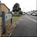
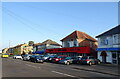
Kinson: Kinson Grove
Kinson Grove forms three sides of a largeish rectangle off Wimborne Road, with the resultant two 90º corners at the far end.
Here we look along it from the eastern end, with the telephone exchange on the corner.
The road sign is a standard one from around 2000-2006, perhaps a little earlier, featuring the borough coat of arms.
This is photo no.230 of a series of 453 in my coronavirus lockdown walking project:
See https://www.geograph.org.uk/article/My-2020-Coronavirus-Lockdown-walking-project for the complete set of photos.
Image: © Chris Downer
Taken: 10 Apr 2020
0.09 miles
2

Northbourne: footpath E45 heads off from Vernalls Close
A late evening view along the dead end of Vernalls Close, with Vernalls Gardens to the left. This left-hand pavement continues as a public footpath to Wimborne Road.
See Image for the view onto the road from the path.
Image: © Chris Downer
Taken: 10 Jul 2016
0.10 miles
3

Northbourne: footpath E45 reaches Vernalls Close
This short public footpath from Wimborne Road arrives at the dead end of Vernalls Close, with Vernalls Gardens off to the right.
See Image for the view up the path from ahead, and Image for the other end of the path, behind us.
Image: © Chris Downer
Taken: 10 Jul 2016
0.10 miles
4
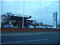
Northbourne: Headless Cross
Nowadays the name Headless Cross is almost completely lost, although the junction is still named as such by the Ordnance Survey on its largest scale maps. It is said to have derived from the original 'T' shape of the junction of East Howe Lane (left) with Wimborne Road, although this is surely a standard junction shape.
In everyone's living memory it has been a standard crossroads with The Broadway, which runs off to the right and must have been connected here at least 50 years ago and possibly very much longer.
It is a major crossroads on the main Wimborne Road through to Kinson, with East Howe Lane being an important suburban route, though unclassified.
The white building on the corner is Northbourne Surgery.
Image: © Chris Downer
Taken: 15 Jul 2015
0.11 miles
5
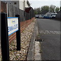
Northbourne: Emma Close
A small infill development of bungalows in the back gardens of some houses in The Broadway. I've noticed that quite a few of these have names which are girls' forenames: Jenni Close and Samantha Close are two other nearby examples.
The sign is a modern one, from 2010-15 when this more modern, abstract emblem rather than the traditional town coat of arms as the working logo of the council.
This is photo no.131 of a series of 453 in my coronavirus lockdown walking project:
See https://www.geograph.org.uk/article/My-2020-Coronavirus-Lockdown-walking-project for the complete set of photos.
Image: © Chris Downer
Taken: 12 Apr 2020
0.11 miles
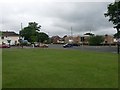
7
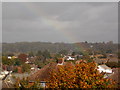
Northbourne: the crock of gold is at Keeble Road
Looking across the rooftops of Kinson/Northbourne as a rainbow reaches Earth roughly at the playpark in Keeble Road, a modern housing estate on a previously vacant plot.
The electricity pylon in the background stands in the middle of a field at about SZ 0764 9720, larger-scale Ordnance Survey maps show the line running a few hundred yards to the north, so presumably it has been realigned in recent years.
Image: © Chris Downer
Taken: 16 Oct 2014
0.12 miles
8

Northbourne: footpath E45 to Vernalls Close
The footpath runs alongside modern flats at 1471-1479 Wimborne Road, previously a vacant grass plot if I recall correctly.
See Image for the path's emergence at the other end.
Image: © Chris Downer
Taken: 10 Jul 2016
0.12 miles
10
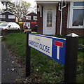
Kinson: Graycot Close
A little late-70s or early 80s development. The house number, 1376a, can only belong to Bournemouth's longest road, Wimborne Road. This row of houses is similar to those in Graycot Close itself, although semi-detached rather than detached, so is probably part of the same development. (If the houses are smaller than those they replaced, that might explain the 'a' suffix.)
The sign is a modern one, from 2010-15 when this more modern, abstract emblem rather than the traditional town coat of arms as the working logo of the council. The no-through-road sign is incorporated into the nameplate.
This is photo no.171 of a series of 453 in my coronavirus lockdown walking project:
See https://www.geograph.org.uk/article/My-2020-Coronavirus-Lockdown-walking-project for the complete set of photos.
Image: © Chris Downer
Taken: 10 Apr 2020
0.13 miles