IMAGES TAKEN NEAR TO
Cedar Avenue, BOURNEMOUTH, BH10 7EF
Introduction
This page details the photographs taken nearby to Cedar Avenue, BH10 7EF by members of the Geograph project.
The Geograph project started in 2005 with the aim of publishing, organising and preserving representative images for every square kilometre of Great Britain, Ireland and the Isle of Man.

There are currently over 7.5m images from over14,400 individuals and you can help contribute to the project by visiting https://www.geograph.org.uk
Image Map
Images are licensed for reuse under creativecommons.org/licenses/by-sa/2.0
Notes
- Clicking on the map will re-center to the selected point.
- The higher the marker number, the further away the image location is from the centre of the postcode.
Image Listing (54 Images Found)
Images are licensed for reuse under creativecommons.org/licenses/by-sa/2.0
Image
Details
Distance
1
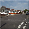
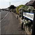
Northbourne: Cedar Avenue
Looking north along Cedar Avenue from its only access road, Austen Avenue – it comes to a dead end both behind us and ahead. Its bungalows are typical of this northern part of Northbourne and Kinson.
Cedar Avenue is one of three roads out of the 451 I visited in my project not to have a nameplate. Google Street View suggests that it has been without one for at least 10 years. However, it does get an honourable mention at the other end of Avebury Avenue: Image
This is photo no.65 of a series of 453 in my coronavirus lockdown walking project:
See https://www.geograph.org.uk/article/My-2020-Coronavirus-Lockdown-walking-project for the complete set of photos.
Image: © Chris Downer
Taken: 12 Apr 2020
0.01 miles
2
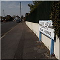
Northbourne: Austen Avenue
Looking along this very short road, not an avenue in the usual sense of being tree lined, which leads only to Cedar Avenue which has a dead end at both ends.
This, its only sign, is of a design that became prevalent in Bournemouth around 1990 and was in use for most of that decade. Supplementary information, such as house numbers or 'leading to' as seen here, are shown in the different font from the road name. Many of these are starting to look a bit shabby now and while the white has deteriorated here, the blue is still ok.
This is photo no.21 of a series of 451 in my coronavirus lockdown walking project:
See https://www.geograph.org.uk/article/My-2020-Coronavirus-Lockdown-walking-project for the complete set of photos.
Image: © Chris Downer
Taken: 12 Apr 2020
0.04 miles
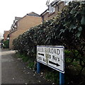
3
Kinson: Keeble Close
The first house of Keeble Close is pictured here, along with the main carriageway of Keeble Road. The little housing estate here was built in the later 1980s and is mainly, possibly all, social housing.
Keeble Close is signposted rather unusually, with the sign opposite rather than on its own corner, and of an unusual square design.
This is photo no.218 of a series of 453 in my coronavirus lockdown walking project:
See https://www.geograph.org.uk/article/My-2020-Coronavirus-Lockdown-walking-project for the complete set of photos.
Image: © Chris Downer
Taken: 12 Apr 2020
0.06 miles
4
Kinson: Keeble Road
Keeble Road always was a short cul-de-sac off Kinson Park Road, leading to a sports ground. In the later 1980s the sports ground was developed for housing and Keeble Road thus extended. Here, we are at the T-shaped end of the road, with odd numbers around the left arm and evens around the right.
The sign is of a design that became prevalent in Bournemouth around 1990 and was in use for most of that decade. Many are starting to look a bit shabby with the blue border fading and the white surface unpeeling, but this one is in pretty good nick if a little dirty. Extra messages, such as the odd/even message here, are always in that different typeface from the street name.
This is photo no.220 of a series of 453 in my coronavirus lockdown walking project:
See https://www.geograph.org.uk/article/My-2020-Coronavirus-Lockdown-walking-project for the complete set of photos.
Image: © Chris Downer
Taken: 12 Apr 2020
0.09 miles
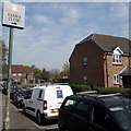
5
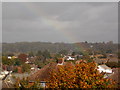
Northbourne: the crock of gold is at Keeble Road
Looking across the rooftops of Kinson/Northbourne as a rainbow reaches Earth roughly at the playpark in Keeble Road, a modern housing estate on a previously vacant plot.
The electricity pylon in the background stands in the middle of a field at about SZ 0764 9720, larger-scale Ordnance Survey maps show the line running a few hundred yards to the north, so presumably it has been realigned in recent years.
Image: © Chris Downer
Taken: 16 Oct 2014
0.11 miles
6
Northbourne: Avebury Avenue
Looking along this short, curved road of desirable bungalows (although there's a house visible also) from its northeast corner.
The road sign dates from 2017/2018: until then, the signage included the words BOURNEMOUTH BOROUGH COUNCIL in smaller type at the top. (Bournemouth Council ceased to exist in April 2019 but the removal of the council name happened before that).
This is photo no.22 of a series of 451 in my coronavirus lockdown walking project:
See https://www.geograph.org.uk/article/My-2020-Coronavirus-Lockdown-walking-project for the complete set of photos.
Image: © Chris Downer
Taken: 12 Apr 2020
0.11 miles
7
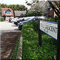
Kinson: Keeble Crescent
Keeble Crescent is a curious name: It is indeed a crescent-shaped road off Keeble Road, but according to some maps only the offshoots leading to the houses are named Keeble Crescent, the actual crescent being part of Keeble Road.
The estate dates from the later 1980s on the site of a sports ground or similar.
This is photo no.218 of a series of 453 in my coronavirus lockdown walking project:
See https://www.geograph.org.uk/article/My-2020-Coronavirus-Lockdown-walking-project for the complete set of photos.
Image: © Chris Downer
Taken: 12 Apr 2020
0.12 miles
8
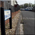
Northbourne: Emma Close
A small infill development of bungalows in the back gardens of some houses in The Broadway. I've noticed that quite a few of these have names which are girls' forenames: Jenni Close and Samantha Close are two other nearby examples.
The sign is a modern one, from 2010-15 when this more modern, abstract emblem rather than the traditional town coat of arms as the working logo of the council.
This is photo no.131 of a series of 453 in my coronavirus lockdown walking project:
See https://www.geograph.org.uk/article/My-2020-Coronavirus-Lockdown-walking-project for the complete set of photos.
Image: © Chris Downer
Taken: 12 Apr 2020
0.14 miles
9
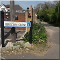
Northbourne: Brecon Close
Really a minor lane leading down to the river Stour from New Road, and containing a few bungalows further down, Brecon Close is heavily used by walkers as it leads to the start of the Bournemouth stretch of the Stour Valley Way, the riverside path leading eventually down to Christchurch Harbour.
The sign is a modern one, dating from around 2014-15, by which time the council had replaced the coloured logo, which had been prone to fading after a while, to simple wording BOURNEMOUTH BOROUGH COUNCIL in smaller type.
This is photo no.47 of a series of 453 in my coronavirus lockdown walking project:
See https://www.geograph.org.uk/article/My-2020-Coronavirus-Lockdown-walking-project for the complete set of photos.
Image: © Chris Downer
Taken: 12 Apr 2020
0.14 miles
10
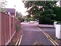
Northbourne: footpath O22 emerges onto Wimborne Road
This public footpath leads from Northbourne Gardens to Wimborne Road, ahead of us. Its second half is a driveway access to 1260 Wimborne Road, which is just to our right, behind 1258 which is on the corner ahead.
See Image for the view behind us to the more 'path-like' footpath, and Image] for a view here from the path itself.
Image: © Chris Downer
Taken: 22 Jun 2016
0.14 miles