IMAGES TAKEN NEAR TO
Headswell Crescent, BOURNEMOUTH, BH10 6LH
Introduction
This page details the photographs taken nearby to Headswell Crescent, BH10 6LH by members of the Geograph project.
The Geograph project started in 2005 with the aim of publishing, organising and preserving representative images for every square kilometre of Great Britain, Ireland and the Isle of Man.

There are currently over 7.5m images from over14,400 individuals and you can help contribute to the project by visiting https://www.geograph.org.uk
Image Map
Images are licensed for reuse under creativecommons.org/licenses/by-sa/2.0
Notes
- Clicking on the map will re-center to the selected point.
- The higher the marker number, the further away the image location is from the centre of the postcode.
Image Listing (114 Images Found)
Images are licensed for reuse under creativecommons.org/licenses/by-sa/2.0
Image
Details
Distance
1
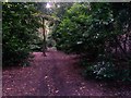
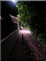
Redhill: passing a singular tree on Sandy Way
Sandy Way is a lane some 630m in length which forms public bridleway O07 between Wimborne Road and Headswell Avenue. At each end, it is a gravel road with a few dwellings but the majority of it is a very rural feeling track in a steep sided, linear wood.
Here, we look northeast along the bridleway in its most secluded and rural.
See Image for the next view along the route ahead, and Image for the next view behind us - each giving links to further photos all along the route.
Image: © Chris Downer
Taken: 6 Jul 2016
0.04 miles
2
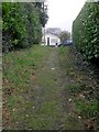
Northbourne: the top of footpath O09
This public footpath extends quite steeply from Georgian Way and comes out just ahead on Headswell Gardens. Rubber nonslip surfacing has been provided all down the grassy path.
See Image for the view behind us.
Image: © Chris Downer
Taken: 5 Mar 2017
0.05 miles
3
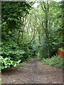
Red Hill, Sandy Way
An oasis of tranquillity, sandwiched between suburbia to the West, and A347 to the East. Bridleway, the upper storey is predominantly oak and ash.
Image: © Mike Faherty
Taken: 26 Jul 2009
0.05 miles
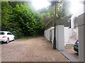
4
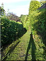
Redhill: footpath O09 to Georgian Way
Perhaps a surprisingly rural looking sight in this suburban context, this footpath leads down to Image from Headswell Crescent and is particularly useful as a route from my flat to the Horse & Jockey, where I frequently meet up with friends - for that reason alone, it is worthy of note. See Image for a view from the bottom.
Careful viewers may discern a grey cat watching me closely as I take this picture, from the first part of the path which is under shade of the neighbouring hedge.
See Image] for the arrival on Headswell Crescent just behind us.
Image: © Chris Downer
Taken: 26 Jul 2013
0.06 miles
5
Redhill: passing 12 Sandy Way
Sandy Way is a lane some 630m in length which forms public bridleway O07 between Wimborne Road and Headswell Avenue. At each end, it is a gravel road with a few dwellings but the majority of it is a very rural feeling track in a steep sided, linear wood.
Here, we pass the last house at this northern end as the road comes to an end and the rural track takes over (there are only even numbers - 4-12 at this end and 86-88 at the other end).
See Image for the view towards us, and Image for the next view behind us - each giving links to further photos all along the route.
Image: © Chris Downer
Taken: 6 Jul 2016
0.06 miles
6
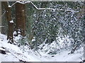
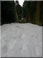
Northbourne: snowy branch over Sandy Way
Looking up this rural looking enclave in the suburbs of Bournemouth, the day after the town's first significant snowfall for three years.
Image: © Chris Downer
Taken: 2 Mar 2018
0.06 miles
7
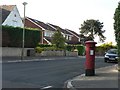
Northbourne: postbox № BH10 291, Headswell Avenue
A George V-reign postbox on the corner of Headswell Avenue and Crescent.
Image: © Chris Downer
Taken: 30 Jun 2008
0.06 miles
8
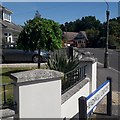
Northbourne: Headswell Crescent
Headswell Crescent forms a standard crescent shape off the eastern side of Headswell Avenue, but at this southern end also crosses it to meet Saxonhurst Road, the next road behind us. It is typical Northbourne - decent, desirable detached housing and a mix of houses and bungalows.
The sign is a modern one - it is only in the last couple of years that Bournemouth Borough Council stopped including its name in smaller type at the top of the sign, perhaps in readiness for local government reorganisation in April 2019 which saw the borough council replaced by BCP (Bournemouth, Christchurch & Poole) council.
This is photo no.186 of a series of 453 in my coronavirus lockdown walking project:
See https://www.geograph.org.uk/article/My-2020-Coronavirus-Lockdown-walking-project for the complete set of photos.
Image: © Chris Downer
Taken: 10 Apr 2020
0.06 miles
9
Redhill: leaving the woods on Sandy Way
Sandy Way is a lane some 630m in length which forms public bridleway O07 between Wimborne Road and Headswell Avenue. At each end, it is a gravel road with a few dwellings but the majority of it is a very rural feeling track in a steep sided, linear wood.
Here, we arrive the last house at this northern end as the rural track road comes to an end and the gravel road takes over alongside the houses (there are only even numbers - 4-12 at this end and 86-88 at the other end).
See Image for the view towards us from ahead, and Image for the next view behind us - each giving links to further photos all along the route.
Image: © Chris Downer
Taken: 6 Jul 2016
0.06 miles
10
Northbourne: cracked ice over snow on footpath O09
Unusually, after significant snow on 1st March, freezing rain fell overnight, resulting in a layer of ice settling on top of the snow. The ice and snow remained distinct from each other, so each footstep produced a loud, satisfying crunch as the ice broke and squished into the snow under it.
In fact, later this evening, I deiced my windscreen, and found the ice easy to lift as large sheets, because it was not in contact with the glass - the snow was sandwiched in between, preserved as snow rather than turning to ice.
See Image for a similar view along this path, in more summery conditions.
Image: © Chris Downer
Taken: 2 Mar 2018
0.06 miles