IMAGES TAKEN NEAR TO
Brierley Road, BOURNEMOUTH, BH10 6EF
Introduction
This page details the photographs taken nearby to Brierley Road, BH10 6EF by members of the Geograph project.
The Geograph project started in 2005 with the aim of publishing, organising and preserving representative images for every square kilometre of Great Britain, Ireland and the Isle of Man.

There are currently over 7.5m images from over14,400 individuals and you can help contribute to the project by visiting https://www.geograph.org.uk
Image Map
Images are licensed for reuse under creativecommons.org/licenses/by-sa/2.0
Notes
- Clicking on the map will re-center to the selected point.
- The higher the marker number, the further away the image location is from the centre of the postcode.
Image Listing (72 Images Found)
Images are licensed for reuse under creativecommons.org/licenses/by-sa/2.0
Image
Details
Distance
1
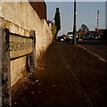
Northbourne: Broadhurst Avenue
A short road within a large area of similar housing - detached bungalows - with the added feature of Image just along to the left.
The sign is a modern one, probably from around 2000, and is not rare in this neck of the woods. It morphed into a later design, including BOURNEMOUTH BOROUGH COUNCIL in smaller letters at the top, and the borough coat of arms on the left.
This is photo no.51 of a series of 453 in my coronavirus lockdown walking project:
See https://www.geograph.org.uk/article/My-2020-Coronavirus-Lockdown-walking-project for the complete set of photos.
Image: © Chris Downer
Taken: 11 Apr 2020
0.05 miles
2
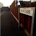
Northbourne: Forton Close
Forton Close is an infill development dating from around 2000, off Saxonhurst Road and turning left and right at the end, behind the back gardens of the latter road.
The sign dates from the time of the development and is a shortlived design. It originally had the borough coat of arms at each end and a slightly shinier oval-ish shape can just be detected now.
This is photo no.148 of a series of 453 in my coronavirus lockdown walking project:
See https://www.geograph.org.uk/article/My-2020-Coronavirus-Lockdown-walking-project for the complete set of photos.
Image: © Chris Downer
Taken: 11 Apr 2020
0.07 miles
3
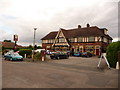
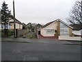
Northbourne: the Crown
A conspicuously large building in the bungalowy back streets of Northbourne, and yet the Crown is not easy to find! The Eldridge Pope pub was originally the Crown & Sceptre but followed the trend of shortening its name about ten years ago, now run by Marston's.
Image: © Chris Downer
Taken: 29 Aug 2010
0.08 miles
4
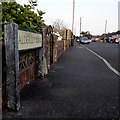
Northbourne: Alderley Road
Looking along this short suburban road in an area of middle-class bungalows.
The sign is a modern one, probably from around 2000, and is not rare in this neck of the woods. It morphed into another design, including BOURNEMOUTH BOROUGH COUNCIL in smaller letters at the top, and the borough coat of arms on the left.
This is photo no.6 of a series of 451 in my coronavirus lockdown walking project:
See https://www.geograph.org.uk/article/My-2020-Coronavirus-Lockdown-walking-project for the complete set of photos.
Image: © Chris Downer
Taken: 11 Apr 2020
0.10 miles
5
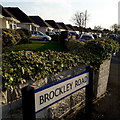
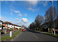
Northbourne: Brockley Road
Looking along a line of bungalows on the east side of Brockley Road, that typify this whole Northbourne area.
The sign is a very recent one, erected since 2017/18 when the council started using plain nameplates, without BOURNEMOUTH BOROUGH COUNCIL in smaller type across the top.
This is photo no.52 of a series of 453 in my coronavirus lockdown walking project:
See https://www.geograph.org.uk/article/My-2020-Coronavirus-Lockdown-walking-project for the complete set of photos.
Image: © Chris Downer
Taken: 11 Apr 2020
0.10 miles
6
Northbourne: Dolphin Avenue
Northbourne is mostly decent, desirable detached houses and bungalows, and it is the latter that we see in the roads around Dolphin Avenue. The unusual name bears no obvious resemblance to the other names around here: Wakefield, Glamis, Pengelly, Brierley, Palfrey and Alderley are the nearest neighbours.
The sign dates from 2010-15 when this more modern, abstract emblem rather than the traditional town coat of arms as the working logo of the council.
This is photo no.109 of a series of 453 in my coronavirus lockdown walking project:
See https://www.geograph.org.uk/article/My-2020-Coronavirus-Lockdown-walking-project for the complete set of photos.
Image: © Chris Downer
Taken: 11 Apr 2020
0.13 miles
7
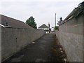
Northbourne: footpath O01 heads for Palfrey Road
Looking along this public footpath between the parallel streets Northbourne Avenue and Palfrey Road, in the direction of the latter.
See Image for the view along the path from the roadside ahead, and Image for the next view on the path behind us.
Image: © Chris Downer
Taken: 10 Jun 2016
0.13 miles
8
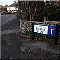
Northbourne: Brierley Close
A tiny cul-de-sac off its namesake Brierley Road, in a large area of desirable detached bungalows.
The sign is of a design dating from around 2005, with the colourful modern emblem replacing the traditional borough coat of arms as the working logo of the council.
This is photo no.49 of a series of 453 in my coronavirus lockdown walking project:
See https://www.geograph.org.uk/article/My-2020-Coronavirus-Lockdown-walking-project for the complete set of photos.
Image: © Chris Downer
Taken: 11 Apr 2020
0.14 miles
9
Northbourne: footpath O01 from Palfrey Road
A public footpath leading from Palfrey Road to the next parallel street, Northbourne Avenue. See Image for the next photo on the path.
Image: © Chris Downer
Taken: 7 Jan 2017
0.14 miles
10
Leybourne Avenue
Leybourne Avenue, at the junction with Brockley Road.
Image: © Peter Kazmierczak
Taken: 7 Mar 2016
0.15 miles