IMAGES TAKEN NEAR TO
Redhill Drive, BOURNEMOUTH, BH10 6AF
Introduction
This page details the photographs taken nearby to Redhill Drive, BH10 6AF by members of the Geograph project.
The Geograph project started in 2005 with the aim of publishing, organising and preserving representative images for every square kilometre of Great Britain, Ireland and the Isle of Man.

There are currently over 7.5m images from over14,400 individuals and you can help contribute to the project by visiting https://www.geograph.org.uk
Image Map
Images are licensed for reuse under creativecommons.org/licenses/by-sa/2.0
Notes
- Clicking on the map will re-center to the selected point.
- The higher the marker number, the further away the image location is from the centre of the postcode.
Image Listing (118 Images Found)
Images are licensed for reuse under creativecommons.org/licenses/by-sa/2.0
Image
Details
Distance
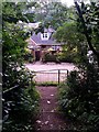
1
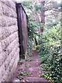
Redhill: start of descent on footpath O19
The Image to Sandy Way has recourse to steps as the gradient steepens alongside the back garden wall of the neighbouring house. It gets steeper, too: see Image for the next view along the path.
Image: © Chris Downer
Taken: 6 Jul 2016
0.02 miles
2
Redhill: footpath O19 from Redhill Drive
Not the most conspicuous of paths, this is a public footpath heading steeply down to Sandy Way.
See Image for the next view along the path.
Image: © Chris Downer
Taken: 6 Jul 2016
0.02 miles
4
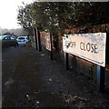
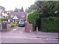
Redhill: Jessopp Close
Just before 7am we look along Jessopp Close, a short, fairly steep cul-de-sac off the crest of Redhill Drive just as it heads down to meet Wimborne Road. We can glimpse the roof of one of the bungalows above the parked cars.
The sign is of a design that became prevalent in Bournemouth around 1990 and was in use for most of that decade. Many are starting to look a bit shabby now, and the blue border of this one has faded somewhat, though the white surface is intact unlike many.
This is photo no.215 of a series of 453 in my coronavirus lockdown walking project:
See https://www.geograph.org.uk/article/My-2020-Coronavirus-Lockdown-walking-project for the complete set of photos.
Image: © Chris Downer
Taken: 12 Apr 2020
0.03 miles
5
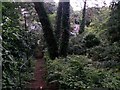
Redhill: descent into woodland on footpath O19
Looking down the steep steps that head down to Sandy Way from Redhill Drive on this public footpath.
See Image for a view up the steps from near the bottom, and Image for the next view on the path behind us.
Image: © Chris Downer
Taken: 6 Jul 2016
0.03 miles
6
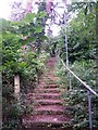
Redhill: up the steps on footpath O19
Looking up this steep public footpath to Redhill Drive from near the bottom of the steps.
See Image for the view down them, and Image for the view behind us onto Sandy Way.
Image: © Chris Downer
Taken: 6 Jul 2016
0.03 miles
7
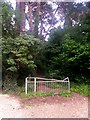
Redhill: footpath O19 ascends from Sandy Way
This public footpath ascends steeply up the wooded side of Sandy Way, bridleway O07, bound for Redhill Drive.
See Image for the view towards us from the footpath ahead; and Image for a view along Sandy Way. Both links provide further links to photos along the paths in all three directions.
Image: © Chris Downer
Taken: 6 Jul 2016
0.04 miles
8
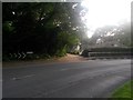
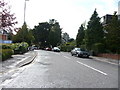
Redhill: Sandy Way from Wimborne Road
Sandy Way is a lane some 630m in length which forms public bridleway O07 between Wimborne Road and Headswell Avenue. At each end, it is a gravel road with a few dwellings but the majority of it is a very rural feeling track in a steep sided, linear wood.
We see it here at its northern end, as it comes out on Wimborne Road, where even numbers 4-12 can be seen on the right.
See Image for the next view along the route, with links to further pictures all the way to the other end.
Image: © Chris Downer
Taken: 6 Jul 2016
0.04 miles
9
Redhill: footpath O19 emerges onto Sandy Way
Looking down the last few steps of this public footpath as it reaches Sandy Way, a bridleway, near its northern end.
See Image for the view up the steep steps behind us, and Image for the view up the path from across the road, with links to photos along the full length of Sandy Way.
Image: © Chris Downer
Taken: 6 Jul 2016
0.04 miles
10
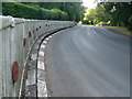
Redhill: reflectors in Wimborne Road
Reflectors and black-and-white highlighted kerbstones would not ordinarily be installed on such a minor back road. These, though, are a reminder of the fact that this section of Wimborne Road was the main thoroughfare northward out of Bournemouth before the Whitelegg Way, parallel and to the northeast, was built in the late 1980s.
This is still a bus route and gives access to the few side roads between Redhill and Northbourne roundabouts, but apart from that it sees very little traffic nowadays.
Image: © Chris Downer
Taken: 26 Jul 2013
0.05 miles