IMAGES TAKEN NEAR TO
Long Road, BOURNEMOUTH, BH10 5NL
Introduction
This page details the photographs taken nearby to Long Road, BH10 5NL by members of the Geograph project.
The Geograph project started in 2005 with the aim of publishing, organising and preserving representative images for every square kilometre of Great Britain, Ireland and the Isle of Man.

There are currently over 7.5m images from over14,400 individuals and you can help contribute to the project by visiting https://www.geograph.org.uk
Image Map
Images are licensed for reuse under creativecommons.org/licenses/by-sa/2.0
Notes
- Clicking on the map will re-center to the selected point.
- The higher the marker number, the further away the image location is from the centre of the postcode.
Image Listing (145 Images Found)
Images are licensed for reuse under creativecommons.org/licenses/by-sa/2.0
Image
Details
Distance
1
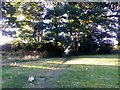
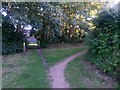
East Howe: leaving Brook Road on footpath E34
Looking along the start of this public footpath, which goes through the kissing gate ahead and along a long, narrowish open space to Kinson.
See Image for the view of and through the gate ahead, and Image for the very start of the path, behind us.
Image: © Chris Downer
Taken: 5 Jul 2016
0.03 miles
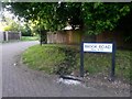
2
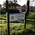
East Howe: Aldridge Road
This sign stands on the grass triangle at the junction of Long Road – the other end of Alrdidge Road also comes out on Long Road, further north. The council houses string along in a straight line, ignoring the bends in the road: hence the grass triangle.
The sign is a Bournemouth Borough one which includes the coat of arms.
This is photo no.7 of a series of 451 in my coronavirus lockdown walking project:
See https://www.geograph.org.uk/article/My-2020-Coronavirus-Lockdown-walking-project for the complete set of photos.
Image: © Chris Downer
Taken: 16 Apr 2020
0.03 miles
3
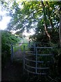
East Howe: kissing gate on footpath E34
Looking north along this public footpath from Brook Road as it enters the linear open space on the way to Kitscroft Road.
See Image for a view towards us from the path ahead, and Image for the next view on the path behind us.
Image: © Chris Downer
Taken: 5 Jul 2016
0.03 miles
4
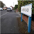
East Howe: Long Road
Long Road is actually not all that long, but I suspect it is someone's surname that gives the road its name. It is a small exclave of the large West Howe council housing estate, leading to Aldridge Road (the first of whose turnings this sign faces) and the detached stub of Leybourne Avenue.
The sign is of a design that became prevalent in Bournemouth around 1990 and was in use for most of that decade. Many are starting to look a bit shabby now, with the blue border fading and the white surface peeling, such as the small patch that has come off this one.
This is photo no.248 of a series of 453 in my coronavirus lockdown walking project:
See https://www.geograph.org.uk/article/My-2020-Coronavirus-Lockdown-walking-project for the complete set of photos.
Image: © Chris Downer
Taken: 16 Apr 2020
0.03 miles
5
East Howe: approaching Brook Road on footpath E34
The Gulliver Trail, connected with ancient smuggling, heads to the right to meet Brook Road, but the mapped public right of way heads straight on, through the gate, arriving on Brook Road a few yards further on.
See Image for a view towards us from ahead, and Image for the next view behind us.
Image: © Chris Downer
Taken: 5 Jul 2016
0.03 miles
6
Kinson: another view of Brook Road allotments
A similar picture to Image, through the gates but looking a bit further round to the right to see more of the plots and less of the building.
Image: © Chris Downer
Taken: 20 Nov 2016
0.04 miles
7
Kinson: some houses have back gates onto footpath E34
Looking along this public footpath, from Brook Road to Kitscroft Road, running through a linear open space. The houses of Aldridge Road back onto it and several have back gates that open out onto the grassland - one can just be made out at the extreme right of the picture.
See Image for the next view along the path ahead, and Image for the next view behind us.
Image: © Chris Downer
Taken: 5 Jul 2016
0.05 miles
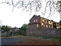
8
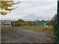
Kinson: Brook Road allotments
This is as much of a view as one can get, the camera pointing through the ironwork of the large main gates. The allotments cover quite a large triangular area, but are hidden by a tall hedgerow on the eastern side, and hemmed in by housing on the west and north sides.
Image: © Chris Downer
Taken: 29 Aug 2016
0.05 miles
9
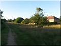
East Howe: to 9-33 Brook Road and footpath E34
Looking along this modern offshoot of Brook Road, on whose main pavement we are standing. This side-road leads to a few houses but also forms the start of a public footpath, heading across the grassed area in the distance, towards Kinson.
I am sure that before this small development was built, the rural feel of the path would have been maintained right up to here.
See Image for the next view along the path.
Image: © Chris Downer
Taken: 5 Jul 2016
0.05 miles
10
Kinson: Black Balls and other graffiti
A disused, tarmacked yard behind a block of flats in Brook Road is daubed with graffiti on its retaining wall. Meanwhile, the upper-floor flats catch the last of the sunshine on this November late-afternoon.
Image: © Chris Downer
Taken: 6 Nov 2016
0.06 miles