IMAGES TAKEN NEAR TO
Kinson Road, BOURNEMOUTH, BH10 5JL
Introduction
This page details the photographs taken nearby to Kinson Road, BH10 5JL by members of the Geograph project.
The Geograph project started in 2005 with the aim of publishing, organising and preserving representative images for every square kilometre of Great Britain, Ireland and the Isle of Man.

There are currently over 7.5m images from over14,400 individuals and you can help contribute to the project by visiting https://www.geograph.org.uk
Image Map
Images are licensed for reuse under creativecommons.org/licenses/by-sa/2.0
Notes
- Clicking on the map will re-center to the selected point.
- The higher the marker number, the further away the image location is from the centre of the postcode.
Image Listing (88 Images Found)
Images are licensed for reuse under creativecommons.org/licenses/by-sa/2.0
Image
Details
Distance
1
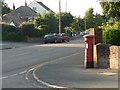
East Howe: postbox № BH10 343, Kinson Road
This George VI-reign postbox stands outside Image
Image: © Chris Downer
Taken: 3 Jul 2008
0.01 miles
2
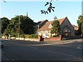
East Howe: Methodist church
Situated on the corner of Kinson Road and (off to the right) East Howe Lane. Also in the picture is Image
Image: © Chris Downer
Taken: 3 Jul 2008
0.01 miles
3
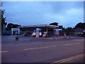
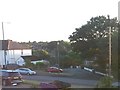
East Howe: filling station in Kinson Road
I bought petrol at this site as recently as Friday 6 May but when I returned a few days later I found it shuttered up and the numerals removed from the sign. Now, a week further on, the sign itself has been removed, the 'Shell' signage has been taken down from the canopy and barriers have been put across the site. Not visible here, an unreachable cashpoint at the far end of the building shines defiantly on.
The closure of this filling station, which was always among the cheapest and pretty busy, would have meant that there was now no such facility between Ringwood Road and Charminster Road.
However, a week later it transpired that the closure was merely a temporary one while the Shell insignia was changed to Esso signage.
Image: © Chris Downer
Taken: 17 May 2011
0.02 miles
4
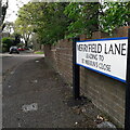
East Howe: Merryfield Lane
A short dead-end road, but a through route for pedestrians cutting off the corner of Kinson Road and East Howe Lane. From the map or on the ground, it is easy to appreciate that this was an original track which would have cut off the same corner when these were all lanes. It retains the 'laney' feel.
The sign is a modern one, dating from around 2014-15, by which time the council had replaced the coloured logo, which had been prone to fading after a while, to simple wording BOURNEMOUTH BOROUGH COUNCIL in smaller type. It also refers to St. Merrin's Close, a short cul-de-sac of council semis.
This is photo no.268 of a series of 453 in my coronavirus lockdown walking project:
See https://www.geograph.org.uk/article/My-2020-Coronavirus-Lockdown-walking-project for the complete set of photos.
Image: © Chris Downer
Taken: 11 Apr 2020
0.04 miles
5
East Howe: Merryfield Lane from Kinson Road
The opposing view to Image, showing the 13m-long public footpath E30, which connects Kinson Road and Merryfield Lane. The public right of way once covered the whole of Merryfield Lane, before it was tarmacked and, presumably, made part of the public highway.
Image: © Chris Downer
Taken: 23 Jul 2016
0.05 miles
6
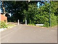
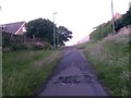
West Howe: Ericksen Road leaves Kinson Road
Looking across Kinson Road towards Ericksen Road, which has only been tarmacked in relatively recent years. It heads down to Moorside Road but is not a through route for vehicles - it does, though, form a segment of public footpath U35.
See Image for the next view along the road, and further links to pictures on footpath U35.
Image: © Chris Downer
Taken: 28 Jun 2016
0.05 miles
7
West Howe: sign for Ericksen Road on footpath U35
Looking along Ericksen Road from its eastern end, on Kinson Road. It forms a public footpath and there are railings ahead to prevent through access for vehicles - see Image
See Image for a view of Ericksen Road from across the road behind us.
Image: © Chris Downer
Taken: 28 Jun 2016
0.05 miles
8
East Howe: footpath E30 from Merryfield Lane
Looking out of the dead end of Merryfield Lane onto Kinson Road. The part between the two is a public footpath, E30, which used to have a more rural feel before Merryfield Lane was tarmacked and Chaldecott Gardens was built. See Image for the view towards us from ahead.
See Image for more discussion on the development of Chaldecott Gardens. Similarly to that, the 1:25,000 mapping still alludes to the public footpath running the length of Merryfield Lane, rather than just being the stub at this end.
Image: © Chris Downer
Taken: 10 Jun 2016
0.05 miles
9
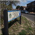
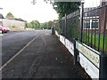
East Howe: Chaldecott Gardens
A late-1980s development of terraced social housing, occupying a rural plot which had a public footpath running through it. A public right of way has been maintained between here and Cartwright Close, the road filling the development from the other side. See Image for more discussion on the right of way.
The road sign is a standard one from around 2000-2006, perhaps a little earlier, featuring the borough coat of arms. It also mentions that the Brook Close is accessed from here: see Image
This is photo no.66 of a series of 453 in my coronavirus lockdown walking project:
See https://www.geograph.org.uk/article/My-2020-Coronavirus-Lockdown-walking-project for the complete set of photos.
Image: © Chris Downer
Taken: 11 Apr 2020
0.07 miles
10
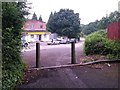
West Howe: approaching a barrier across Ericksen Road
Looking up Ericksen Road, which has been tarmacked only in relatively recent years, as it heads towards Kinson Road. The road forms part of public footpath U35.
See Image for a downhill view from the barrier, and Image for further views of footpath U35 behind us.
Image: © Chris Downer
Taken: 28 Jun 2016
0.07 miles