IMAGES TAKEN NEAR TO
East Howe Lane, BOURNEMOUTH, BH10 5JG
Introduction
This page details the photographs taken nearby to East Howe Lane, BH10 5JG by members of the Geograph project.
The Geograph project started in 2005 with the aim of publishing, organising and preserving representative images for every square kilometre of Great Britain, Ireland and the Isle of Man.

There are currently over 7.5m images from over14,400 individuals and you can help contribute to the project by visiting https://www.geograph.org.uk
Image Map
Images are licensed for reuse under creativecommons.org/licenses/by-sa/2.0
Notes
- Clicking on the map will re-center to the selected point.
- The higher the marker number, the further away the image location is from the centre of the postcode.
Image Listing (224 Images Found)
Images are licensed for reuse under creativecommons.org/licenses/by-sa/2.0
Image
Details
Distance
1
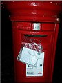
East Howe: a message to the postie
It is just before midnight on a Friday night, and a note has been attached to Image which the postman will hopefully see when he empties the box tomorrow.
It says:
FAO Postie,
My daughter put an A5 envelope in the box addressed to the Town Hall
but forgot to seal the envelope!!
Please would you be so kind as to sellotape it shut for me.
I work at Winton D.O. [Delivery Office] so I know I'm being a pain but would really appreciate your help?"
Image: © Chris Downer
Taken: 14 Oct 2016
0.01 miles
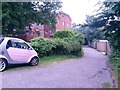
2
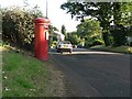
East Howe: postbox № BH10 80, East Howe Lane
An Elizabeth II-reign postbox in East Howe Lane, close to the corner of Western Avenue, which has been partially set into a low brick-built edging.
Image: © Chris Downer
Taken: 30 Jun 2008
0.03 miles
3
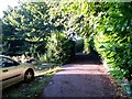
Northbourne: raised pavement in East Howe Lane
This section of East Howe Lane has two pavements, one alongside the road and another outside the bungalow frontages, separated by a steep grass bank about six feet in height.
Image: © Chris Downer
Taken: 25 Dec 2010
0.03 miles
4
Northbourne: grass and trees by Western Avenue
The three westernmost junctions of Western Avenue - with Gillam Road (background), Western Close (directly in front of us) and East Howe Lane (behind us) - are surrounded by large grassed areas containing a few oak trees.
Image: © Chris Downer
Taken: 25 Dec 2010
0.03 miles
5
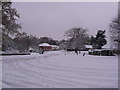
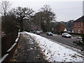
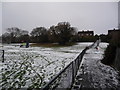
Northbourne: bottom end of Western Avenue
Looking from the Gillam Road turning after Bournemouth received its heaviest snowfall for 17 years overnight.
Image: © Chris Downer
Taken: 2 Dec 2010
0.04 miles
6
East Howe: footpath E39 to Puck?s Dell
This is a driveway access to the garages at the backs of gardens in East Howe Lane, but it is also a public footpath leading to Image
See Image] for the next view along the path and Image for the far end of the drive, with the entrance to the Dell.
Image: © Chris Downer
Taken: 10 Jun 2016
0.04 miles
7
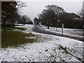
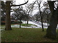
Northbourne: looking up Western Avenue
A view in the opposite direction to Image
Bournemouth experienced heavy snowfall on the night of 2-3 December and further snow on the 18th and 20th, during a long spell in which the temperature has struggled to exceed freezing point at all. Even when it did, during the daytime of the 20th - bringing very heavy rain - it was not substantial enough to thaw all of the snow and it soon froze over again as the temperature plummeted once more.
Here we look up Western Avenue from the East Howe Lane end. East Howe Lane was gritted, being a bus route, and we can see here that the traffic entering Western Avenue here has freed the left-hand side of ice, but downhill traffic has not caused a similar effect on the right. This is the clearest I have seen Western Avenue, in terms of ice, for three weeks and only last weekend I had to turn back on this hill because the car ahead of me had become stranded.
Temperatures are expected to rise to as much as a balmy 8 or 9 degrees by Monday or Tuesday, though.
Image: © Chris Downer
Taken: 25 Dec 2010
0.04 miles
8
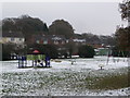
Northbourne: playpark behind East Howe Lane
Pictured on Christmas morning, this playpark is between the back gardens of properties in East Howe Lane (in the background) and Long Road (behind us). We are stood on the path that runs between the two roads. To the north of the path is a sports field (see Image).
Image: © Chris Downer
Taken: 25 Dec 2010
0.05 miles
9
Northbourne: path linking East Howe Lane and Long Road
Looking along this path, from the East Howe Lane end, towards Long Road whose houses we see in the background.
To the left is Image while to the right beyond the fence is Image
Image: © Chris Downer
Taken: 25 Dec 2010
0.05 miles
10
East Howe: midway along footpath E39
This public footpath is less inspiring than its destination. It comprises a rear garage access driveway, but it comes out in the little public open space known as Puck's Dell.
See Image for the far end of the path, and Image for the end behind us as it enters the Dell.
Image: © Chris Downer
Taken: 5 Jul 2016
0.05 miles