IMAGES TAKEN NEAR TO
Cartwright Close, BOURNEMOUTH, BH10 5HL
Introduction
This page details the photographs taken nearby to Cartwright Close, BH10 5HL by members of the Geograph project.
The Geograph project started in 2005 with the aim of publishing, organising and preserving representative images for every square kilometre of Great Britain, Ireland and the Isle of Man.

There are currently over 7.5m images from over14,400 individuals and you can help contribute to the project by visiting https://www.geograph.org.uk
Image Map
Images are licensed for reuse under creativecommons.org/licenses/by-sa/2.0
Notes
- Clicking on the map will re-center to the selected point.
- The higher the marker number, the further away the image location is from the centre of the postcode.
Image Listing (89 Images Found)
Images are licensed for reuse under creativecommons.org/licenses/by-sa/2.0
Image
Details
Distance
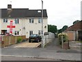
1
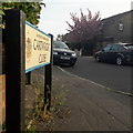
East Howe: Cartwright Close
A late-1980s development of terraced social housing, occupying a rural plot which had a public footpath running through it. A public right of way has been maintained between here and Chaldecott Gardens, the road filling the development from the other side. See Image for more discussion on the right of way.
The road sign is a standard one from around 2000-2006, perhaps a little earlier, featuring the borough coat of arms.
This is photo no.62 of a series of 453 in my coronavirus lockdown walking project:
See https://www.geograph.org.uk/article/My-2020-Coronavirus-Lockdown-walking-project for the complete set of photos.
Image: © Chris Downer
Taken: 12 Apr 2020
0.01 miles
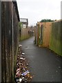
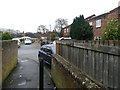
2
East Howe: footpath E32 reaches Cartwright Close
Footpath E32 is a public right of way between Cartwright Close and Chaldecott Gardens. Here, we see its northern end as it arrives at the former.
The two roads mentioned form a small housing estate built in the late 1980s, prior to which this was a rather rural looking path which has thus been shortened thanks to the two roads. Current 1:25,000 mapping still alludes to the original longer route of the footpath, appearing to go right through some of the houses.
See Image for the view up the path from ahead, and Image for the next photo on the path behind us, with links to further photos on the route.
Image: © Chris Downer
Taken: 10 Jun 2016
0.01 miles
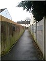
3
East Howe: footpath E32 from Chaldecott Gardens
This public footpath heads from the bend in Cartwright Close to Chaldecott Gardens (and, indirectly, to Sunningdale Crescent).
The first two roads mentioned form a small housing estate built in the late 1980s, prior to which this was a rather rural looking path which has thus been shortened thanks to the two roads. Current 1:25,000 mapping still alludes to the original longer route of the footpath, appearing to go right through some of the houses.
See Image for the view onto the road from the path ahead, with links to further photos along the route.
Image: © Chris Downer
Taken: 8 Mar 2017
0.02 miles
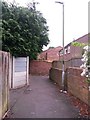
4
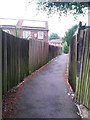
East Howe: footpath E32 between Chaldecott Gardens and Cartwright Close
Footpath E32 is a public right of way between Cartwright Close and Chaldecott Gardens. Here, we see it midway along its length.
The two roads mentioned form a small housing estate built in the late 1980s, prior to which this was a rather rural looking path which has thus been shortened thanks to the two roads. Current 1:25,000 mapping still alludes to the original longer route of the footpath, appearing to go right through some of the houses.
See Image for a picture of the end of the path ahead, and Image for the next segment behind us.
Image: © Chris Downer
Taken: 10 Jun 2016
0.03 miles
5
East Howe: footpath E32 goes slightly off-straight
Heading from Chaldecott Gardens to Cartwright Close, this public footpath takes a slightly drunken course as it skirts between the various back gardens.
The two roads mentioned form a small housing estate built in the late 1980s, prior to which this was a rather rural looking path which has thus been shortened thanks to the two roads. Current 1:25,000 mapping still alludes to the original longer route of the footpath, appearing to go right through some of the houses.
See Image for the next view on the path ahead, and Image for the next view behind us - each with links to further photos along the mentioned routes.
Image: © Chris Downer
Taken: 8 Mar 2017
0.03 miles
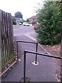
6
East Howe: footpath E33 to Sunningdale Crescent
This public footpath is a short one, branching off footpath E32 (at our feet) and heading the short distance to Sunningdale Crescent, which we see ahead.
See Image for the view towards us from the road ahead, and Image for the view past this junction on footpath E32 (with links to further photos on that route).
Image: © Chris Downer
Taken: 8 Mar 2017
0.04 miles
7
East Howe: footpaths E32 and E33 meet
Footpath E32 is a public right of way between Cartwright Close and Chaldecott Gardens. Here, we see it towards its southern end, just as another path joins it on the left (see Image).
The two roads mentioned form a small housing estate built in the late 1980s, prior to which this was a rather rural looking path which has thus been shortened thanks to the two roads. Current 1:25,000 mapping still alludes to the original longer route of the footpath, appearing to go right through some of the houses.
See Image for a picture of the end of the path, just around the corner ahead, and Image for the next segment behind us.
Image: © Chris Downer
Taken: 10 Jun 2016
0.05 miles
8
East Howe: to 9-33 Brook Road and footpath E34
Looking along this modern offshoot of Brook Road, on whose main pavement we are standing. This side-road leads to a few houses but also forms the start of a public footpath, heading across the grassed area in the distance, towards Kinson.
I am sure that before this small development was built, the rural feel of the path would have been maintained right up to here.
See Image for the next view along the path.
Image: © Chris Downer
Taken: 5 Jul 2016
0.05 miles
9
East Howe: footpath E33 from Sunningdale Crescent
This small path leads to another public footpath, E32, to provide a link with Chaldecott Gardens (leading to Brook Road) and Cartwright Close (leading to Kinson Road).
See Image for the view towards us from the far end of the path, andImage for a picture of the latter path at the point that the two paths meet.
The 2016 European Cup football event starts today, hence the England flag flying next door but one to the footpath.
Image: © Chris Downer
Taken: 10 Jun 2016
0.05 miles
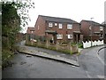
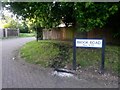
10
East Howe: footpath E32 reaches Chaldecott Gardens
Looking out onto the T-shaped dead end of Chaldecott Gardens, where this public footpath from Cartwright Close emerges. Immediately behind us, the path takes a right-angled turn to head to our right.
The two roads mentioned form a small housing estate built in the late 1980s, prior to which this was a rather rural looking path which has thus been shortened thanks to the two roads. Current 1:25,000 mapping still alludes to the original longer route of the footpath, appearing to go right through some of the houses.
See Image for the view towards us from opposite, and Image for the next view on the path behind us, with links to further photos along the route.
Image: © Chris Downer
Taken: 8 Mar 2017
0.05 miles