IMAGES TAKEN NEAR TO
St. Boniface Gardens, BOURNEMOUTH, BH10 5FE
Introduction
This page details the photographs taken nearby to St. Boniface Gardens, BH10 5FE by members of the Geograph project.
The Geograph project started in 2005 with the aim of publishing, organising and preserving representative images for every square kilometre of Great Britain, Ireland and the Isle of Man.

There are currently over 7.5m images from over14,400 individuals and you can help contribute to the project by visiting https://www.geograph.org.uk
Image Map
Images are licensed for reuse under creativecommons.org/licenses/by-sa/2.0
Notes
- Clicking on the map will re-center to the selected point.
- The higher the marker number, the further away the image location is from the centre of the postcode.
Image Listing (61 Images Found)
Images are licensed for reuse under creativecommons.org/licenses/by-sa/2.0
Image
Details
Distance
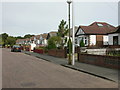
1
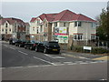
East Howe, building work
At the junction of Hillview Road and Doveshill Crescent, on the site of a former convent Image; 64 affordable flats being built. http://www.davewells.net/New-Developments/New-Development.aspx?Id=100
Image: © Mike Faherty
Taken: 21 Sep 2009
0.01 miles
2
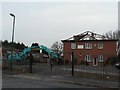
Ensbury Park: St. Boniface Convent
A house of prayer and retreat, according to the sign on the front, but not for much longer.
Image: © Chris Downer
Taken: 24 Feb 2008
0.01 miles
3
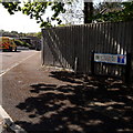
Northbourne: Doveshill Gardens
The position of the sign, towards the middle rather than the point of the triangular pavement entrance, leaves us with just a glimpse of the bungalows that are to be found down there.
The road sign is a standard one from around 2000-2006, perhaps a little earlier, featuring the borough coat of arms. A no-through-road sign is incorporated into the nameplate, whereas there would originally have been a standalone one on the vacant post to the left (see Image for an example of such arrangement).
This is photo no.111 of a series of 453 in my coronavirus lockdown walking project:
See https://www.geograph.org.uk/article/My-2020-Coronavirus-Lockdown-walking-project for the complete set of photos.
Image: © Chris Downer
Taken: 19 Apr 2020
0.08 miles
4
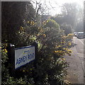
Northbourne: Abney Road
Looking up Abney Road from the Howeth Road end, it looks deceptively rural thanks to a patch of gorse and bramble on the corner where the sign is situated.
The sign is a Bournemouth Borough one with the emblem introduced in around 2013.
This is photo no.2 of a series of 451 in my coronavirus lockdown walking project:
See https://www.geograph.org.uk/article/My-2020-Coronavirus-Lockdown-walking-project for the complete set of photos.
Image: © Chris Downer
Taken: 11 Apr 2020
0.08 miles
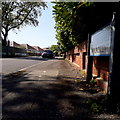
5
East Howe, Hillview Road
A road populated mainly by 1930s bungalows.
Image: © Mike Faherty
Taken: 21 Sep 2009
0.11 miles
6
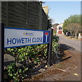
Ensbury Park: Howeth Close
A short cul-de-sac of maybe 1970s housing off the major side-road, Howeth Road.
The sign is a modern one, from 2010-15 when this more modern, abstract emblem rather than the traditional town coat of arms as the working logo of the council.
This is photo no.206 of a series of 453 in my coronavirus lockdown walking project:
See https://www.geograph.org.uk/article/My-2020-Coronavirus-Lockdown-walking-project for the complete set of photos.
Image: © Chris Downer
Taken: 11 Apr 2020
0.14 miles
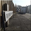
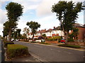
7
Northbourne: Doveshill Crescent
Doveshill Crescent describes a definite crescent shape, although this end comes out on Western Avenue and the far end onto Hill View Road. It possesses detached houses on the inside of the bend and bungalows, as seen in the background, on the outside.
This is photo no.110 of a series of 453 in my coronavirus lockdown walking project:
See https://www.geograph.org.uk/article/My-2020-Coronavirus-Lockdown-walking-project for the complete set of photos.
Image: © Chris Downer
Taken: 19 Apr 2020
0.14 miles
8
Ensbury Park: Beverley Gardens
The parked van allows us only a glimpse along this snaking no-through road, but that glimpse tells us that it consists of desirable detached houses and is not a modern cul-de-sac like many of the infill developments in the area.
The sign also tells us that the road isn't modern: it looks like an ordinary 1980s sign mounted on tubular steel (such as the one at Image), but careful scrutiny will tell us that the lettering and black border is embossed in the metalwork and not put on adhesively like the more modern variety. This makes it one of the older, perhaps 1960s, nameplates.
This is photo no.39 of a series of 451 in my coronavirus lockdown walking project:
See https://www.geograph.org.uk/article/My-2020-Coronavirus-Lockdown-walking-project for the complete set of photos.
Image: © Chris Downer
Taken: 11 Apr 2020
0.15 miles
9
Leybourne Avenue
Situated on what was once the airfield at RAF Winton and later Ensbury Park racecourse.
Image: © Peter Kazmierczak
Taken: 7 Mar 2016
0.15 miles
10
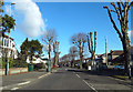
Northbourne: Leybourne Avenue
A fairly main road, flanked by pollarded trees and relatively upmarket houses. Being a bus route, parking on both sides sometimes causes delays as traffic has to let each other pass, but in the last week or two double yellow lines have been painted on the far side.
Image: © Chris Downer
Taken: 23 Oct 2010
0.16 miles