IMAGES TAKEN NEAR TO
Hill View Road, BOURNEMOUTH, BH10 5BJ
Introduction
This page details the photographs taken nearby to Hill View Road, BH10 5BJ by members of the Geograph project.
The Geograph project started in 2005 with the aim of publishing, organising and preserving representative images for every square kilometre of Great Britain, Ireland and the Isle of Man.

There are currently over 7.5m images from over14,400 individuals and you can help contribute to the project by visiting https://www.geograph.org.uk
Image Map
Images are licensed for reuse under creativecommons.org/licenses/by-sa/2.0
Notes
- Clicking on the map will re-center to the selected point.
- The higher the marker number, the further away the image location is from the centre of the postcode.
Image Listing (62 Images Found)
Images are licensed for reuse under creativecommons.org/licenses/by-sa/2.0
Image
Details
Distance
1
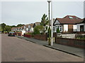
East Howe, Hillview Road
A road populated mainly by 1930s bungalows.
Image: © Mike Faherty
Taken: 21 Sep 2009
0.02 miles
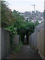
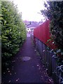
2
Northbourne: footpath E42 arrives on Hill View Road
This public footpath heads quite steeply up from Howeth Road, emerging here onto Hill View Road.
See Image for the view down the path from the roadside ahead, and Image for the next view on the path behind us.
Image: © Chris Downer
Taken: 7 Jan 2017
0.06 miles
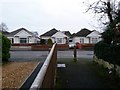
3
Northbourne: Badgers Walk
We just peek at the modern infill bungalows down this steep little road near the dead end of Hill View Road. I am not sure when it was built but the early 2000s is likely.
The sign dates from 2008 and has the phrases PRIVATE ROAD and NOS 1-5 in addition to the road name, plus a no-through-road sign.
This is photo no.23 of a series of 451 in my coronavirus lockdown walking project:
See https://www.geograph.org.uk/article/My-2020-Coronavirus-Lockdown-walking-project for the complete set of photos.
Image: © Chris Downer
Taken: 12 Apr 2020
0.07 miles
4
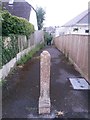
Northbourne: footpath E42 from Hill View Road
A single, old fashioned post stands at the top of this relatively steep public footpath that heads down to Howeth Road.
See Image for the view towards us onto the road, and Image for the next view on the path ahead, with links to further photos.
Image: © Chris Downer
Taken: 10 Jun 2016
0.08 miles
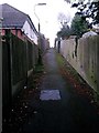
5
Northbourne: a little way down footpath E42
This public footpath runs from Hill View Road quite steeply down to Howeth Road. From a little way down, we get a good view of the housing on the surrounding slopes and see how Hill View Road got its name.
See Image] for the end of the path behind us, and Image for the view towards us from just beyond the lamppost.
Image: © Chris Downer
Taken: 10 Jun 2016
0.08 miles
6
Northbourne: uphill on footpath E42
This public footpath heads quite steeply uphill, as can be gauged from the fence panels on the left, from Howeth Road to Hill View Road.
See Image for the reciprocal downhill view, and Image for the view behind us.
Image: © Chris Downer
Taken: 7 Jan 2017
0.08 miles
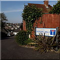
7
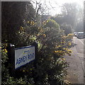
Northbourne: Abney Road
Looking up Abney Road from the Howeth Road end, it looks deceptively rural thanks to a patch of gorse and bramble on the corner where the sign is situated.
The sign is a Bournemouth Borough one with the emblem introduced in around 2013.
This is photo no.2 of a series of 451 in my coronavirus lockdown walking project:
See https://www.geograph.org.uk/article/My-2020-Coronavirus-Lockdown-walking-project for the complete set of photos.
Image: © Chris Downer
Taken: 11 Apr 2020
0.09 miles
8
Northbourne: footpath E42 from Howeth Road
Looking across Howeth Road towards a public footpath which heads uphill at quite a gradient to Hill View Road.
See Image for the view towards us from partway up the path, with links to further photos on the path.
Image: © Chris Downer
Taken: 7 Jan 2017
0.09 miles
9
Northbourne: footpath E42 reaches Howeth Road
A bulging hedge doesn't get in the way as we walk down this public footpath from Hill View Road.
See Image for a view up the path from across the road ahead, and Image for the next view on the path behind us.
Image: © Chris Downer
Taken: 10 Jun 2016
0.10 miles
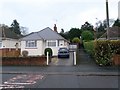
10

Northbourne: Western Avenue
A typical Northbourne street of bungalows, viewed the morning after substantial overnight snowfall - Bournemouth's heaviest for 17 years.
Image: © Chris Downer
Taken: 2 Dec 2010
0.10 miles