IMAGES TAKEN NEAR TO
Kingsbere Avenue, BOURNEMOUTH, BH10 4DL
Introduction
This page details the photographs taken nearby to Kingsbere Avenue, BH10 4DL by members of the Geograph project.
The Geograph project started in 2005 with the aim of publishing, organising and preserving representative images for every square kilometre of Great Britain, Ireland and the Isle of Man.

There are currently over 7.5m images from over14,400 individuals and you can help contribute to the project by visiting https://www.geograph.org.uk
Image Map
Images are licensed for reuse under creativecommons.org/licenses/by-sa/2.0
Notes
- Clicking on the map will re-center to the selected point.
- The higher the marker number, the further away the image location is from the centre of the postcode.
Image Listing (80 Images Found)
Images are licensed for reuse under creativecommons.org/licenses/by-sa/2.0
Image
Details
Distance
1
Ensbury Park: Kingsbere Avenue
A steepish road descending from the main Kinson Road to Priestley Road, lined with bungalows typical of Ensbury Park and with a low hedge between pavement and roadway.
The sign is of a design that became prevalent in Bournemouth around 1990 and was in use for most of that decade. Many are starting to look a bit shabby now, the white surface often starting to peel as here, though the blue border has seen little fading unlike many.
This is photo no.223 of a series of 453 in my coronavirus lockdown walking project:
See https://www.geograph.org.uk/article/My-2020-Coronavirus-Lockdown-walking-project for the complete set of photos.
Image: © Chris Downer
Taken: 14 Apr 2020
0.01 miles
2
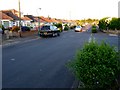
Kingsbere Avenue
View east along the bungalow lined estate road. The road going off on the right is Noel Rd. Kingsbere is the fictitious name Thomas hardy gave to the town of Bere Regis in his novel Tess of the Durbervilles.
Image: © Nigel Mykura
Taken: 23 Apr 2011
0.01 miles
3
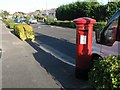
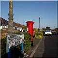
East Howe: postbox № BH10 322, Kingsbere Avenue
This George V-reign postbox is situated in the bungalowy area of East Howe, in Kingsbere Avenue. It has the shadow of a lamppost running right down it at the moment.
Image: © Chris Downer
Taken: 3 Jul 2008
0.02 miles
4

Ensbury Park: Montrose Drive
A cul-de-sac of bungalows off Priestley Road.
The sign tells us that the road isn't modern: it looks like an ordinary 1980s sign mounted on tubular steel (such as the one at Image), but careful scrutiny will tell us that the lettering and black border is embossed in the metalwork and not put on adhesively like the more modern variety. This makes it one of the older, perhaps 1960s, nameplates.
This is photo no.277 of a series of 451 in my coronavirus lockdown walking project:
See https://www.geograph.org.uk/article/My-2020-Coronavirus-Lockdown-walking-project for the complete set of photos.
Image: © Chris Downer
Taken: 15 Apr 2020
0.06 miles
5
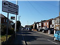
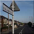
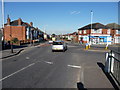
Bournemouth : Columbia Road
Approaching Kinson Road with this sign showing directions to other parts of the town.
Image: © Lewis Clarke
Taken: 8 Mar 2010
0.08 miles
6
Ensbury Park: Columbia Road
One of the main thoroughfares of Bournemouth's northern suburbs, this is one of the longest roads in my 2km circle and we are looking at it from the pedestrian island of the little roundabout at its western end. The lockdown restrictions provide us with an image containing only one car – almost unthinkable in daylight hours!
The sign is a more or less standard one from recent times, affixed to the lamppost on the traffic island. As it is in the middle of the road, it is double-sided.
This is photo no.77 of a series of 453 in my coronavirus lockdown walking project:
See https://www.geograph.org.uk/article/My-2020-Coronavirus-Lockdown-walking-project for the complete set of photos.
Image: © Chris Downer
Taken: 12 Apr 2020
0.08 miles
7
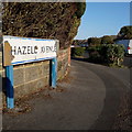
Ensbury Park: Hazell Avenue
Looking around the corner from Noel Road down Hazell Avenue from its top end. We glimpse the bungalows which are prevalent in this area, and also the low hedges which separate each pavement from the carriageway.
The sign is of a design that became prevalent in Bournemouth around 1990 and was in use for most of that decade. Many are starting to look a bit shabby now, and this one is a prime example of both deteriorations: the blue border fading and the white surface unpeeling.
This is photo no.181 of a series of 453 in my coronavirus lockdown walking project:
See https://www.geograph.org.uk/article/My-2020-Coronavirus-Lockdown-walking-project for the complete set of photos.
Image: © Chris Downer
Taken: 14 Apr 2020
0.08 miles
8
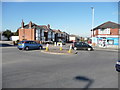
Bournemouth : Kinson Road Roundabout
A roundabout here on Kinson Road with the only other exit to Columbia Road.
Image: © Lewis Clarke
Taken: 8 Mar 2010
0.09 miles
9
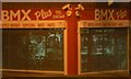
BMX shop by night
This shop on the left-hand corner of the Wonderholm Parade has been empty for a couple of years but has recently been opened as a BMX shop. When the shop is closed, by day the shutters are all that can be seen, but by night, small slots in the shutters along with low level interior lighting allow an intriguingly lit peek at what's inside.
Image: © Chris Downer
Taken: 7 Oct 2007
0.09 miles
10
Bournemouth : Kinson Road Roundabout
A roundabout which leads straight on to Kinson Road or you can turn right from here onto Columbia Road.
Image: © Lewis Clarke
Taken: 8 Mar 2010
0.09 miles