IMAGES TAKEN NEAR TO
Kennion Street, BRADFORD, BD5 0NF
Introduction
This page details the photographs taken nearby to Kennion Street, BD5 0NF by members of the Geograph project.
The Geograph project started in 2005 with the aim of publishing, organising and preserving representative images for every square kilometre of Great Britain, Ireland and the Isle of Man.

There are currently over 7.5m images from over14,400 individuals and you can help contribute to the project by visiting https://www.geograph.org.uk
Image Map
Images are licensed for reuse under creativecommons.org/licenses/by-sa/2.0
Notes
- Clicking on the map will re-center to the selected point.
- The higher the marker number, the further away the image location is from the centre of the postcode.
Image Listing (165 Images Found)
Images are licensed for reuse under creativecommons.org/licenses/by-sa/2.0
Image
Details
Distance
1
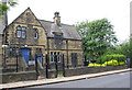
All Saints' Primary School, Kennion Street
There is an Ordnance Survey benchmark Image on the step in the bevelled stone course in the house wall visible past the right hand post of the right hand metal gate
Image: © Roger Templeman
Taken: 26 Jun 2017
0.01 miles
2
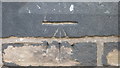
OS Cut Benchmark on All Saint's Primary School, Kennion Street
This is to be found on what was No2 Kennion Street, but is now part of the school. Photographed on a Saturday afternoon, through the fence, at 20x zoom. Details of the mark at http://www.bench-marks.org.uk/bm86339
Image: © Stephen Armstrong
Taken: 4 Nov 2017
0.01 miles
3
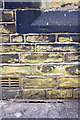
Benchmark on #2 Kennion Street (All Saints Primary School)
Ordnance Survey cut mark benchmark described on the Bench Mark Database at www.bench-marks.org.uk/bm86339
Image: © Roger Templeman
Taken: 26 Jun 2017
0.01 miles
4
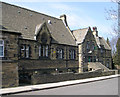
All Saints C of E Primary School - Kennion Street
Image: © Betty Longbottom
Taken: 7 Apr 2007
0.03 miles
5
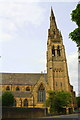
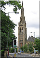
All Saints' Church, from Little Horton Lane
There is an Ordnance Survey benchmark Image on the buttress on the right hand side of the tower. The spire is an OS intersected station trig point, http://trigpointing.uk/trig/14257
Image: © Roger Templeman
Taken: 26 Jun 2017
0.04 miles
6
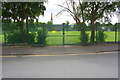
Sports field on south side of Trinity Road with All Saints Church in background
Ordnance Survey documents indicate that in 1956 a benchmark levelled at 136.794m above Newlyn Datum was verified on a gatepost at this entrance. See www.bench-marks.org.uk/bm68329
Image: © Roger Templeman
Taken: 26 Jun 2017
0.04 miles
8
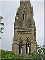
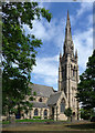
Bradford - All Saints Church - base of spire
Viewed from the south.
Image: © Dave Bevis
Taken: 29 Jun 2013
0.04 miles
9
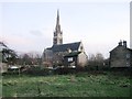
Bradford - All Saints Church
For an alternative view, please see Betty Longbottom's Image
Image: © Dave Bevis
Taken: 29 Jun 2013
0.04 miles
10
All Saints, Little Horton Green, Bradford
By Mallinson & Healey, 1861-63, completed by T.H. & F. Healey, 1863-64. Dec style. The tower and spire are most impressive. Grade II* listed.
Image: © Stephen Richards
Taken: 15 Jun 2012
0.04 miles