IMAGES TAKEN NEAR TO
Undercliffe Lane, BRADFORD, BD3 0DU
Introduction
This page details the photographs taken nearby to Undercliffe Lane, BD3 0DU by members of the Geograph project.
The Geograph project started in 2005 with the aim of publishing, organising and preserving representative images for every square kilometre of Great Britain, Ireland and the Isle of Man.

There are currently over 7.5m images from over14,400 individuals and you can help contribute to the project by visiting https://www.geograph.org.uk
Image Map (Loading...)


Getting Data...Please wait
Leaflet Map data © OpenStreetMap
Images are licensed for reuse under creativecommons.org/licenses/by-sa/2.0
Notes
- Clicking on the map will re-center to the selected point.
- The higher the marker number, the further away the image location is from the centre of the postcode.
Image Listing (293 Images Found)
Images are licensed for reuse under creativecommons.org/licenses/by-sa/2.0
Image
Details
Distance
1
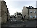
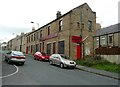
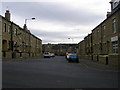
Heap Lane, Bradford
Things have changed a bit since my very first Geograph image from August 2005 Image Cumberland House was demolished in 2009, Ruth House was externally refurbished in 2010 and St. Mary's Church, although the building is still there, has not been a church since 2006 - it is now a banqueting hall.
Image: © Stephen Armstrong
Taken: 30 Nov 2021
0.01 miles
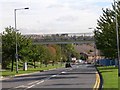
2
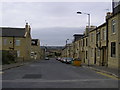
Nuttall Road
From Butler Street West down to Barkerend Road.
Image: © Stephen Armstrong
Taken: 6 Sep 2009
0.02 miles
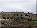
3
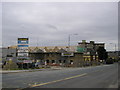
Housing Development, Otley Road, Bradford BD3
A new development of 18 houses, and a shop with apartment above, being built on the site formerly occupied by Cumberland House. The building below used to be the Yorkshire Bank. It closed several years ago and has stood empty most of the time since.
Image: © Stephen Armstrong
Taken: 6 Sep 2009
0.03 miles
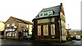
4
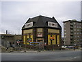
Former Yorkshire Bank, Otley Road, Bradford BD3
Closed for several years, and empty most of that time except for a few months when it opened as a carpet shop. As you can see here Image, it's in the middle of a new housing development.
Image: © Stephen Armstrong
Taken: 6 Sep 2009
0.03 miles
5
Community Church, Heap Lane, Bradford
Image: © Humphrey Bolton
Taken: 21 Oct 2011
0.04 miles
7
Pollard Park Evangelical Church, Heap Lane
A view which, up to a few months ago, (when they demolished Cumberland House), hadn't been possible since the mid 1960s. Taken from Otley Road.
Image: © Stephen Armstrong
Taken: 6 Sep 2009
0.04 miles
8
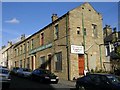
Former Yorkshire Bank Building, Otley Road, Bradford
Vacant for many years, except for a few months in the early 2000s when it opened as a carpet shop. Currently "To Let", as it has been since the carpet shop closed. Once one of two banks in the area, the other being Lloyds 100 yards away at the corner of Barkerend Road - that is also closed but the building is in now a banner printing business.
Image: © Stephen Armstrong
Taken: 16 Dec 2022
0.04 miles
9
Hillside Terrace
View from Nuttall Road
Image: © Stephen Armstrong
Taken: 6 Sep 2009
0.04 miles
10
Pollard Park Evangelical Church - Heap Lane
Image: © Betty Longbottom
Taken: 18 Oct 2007
0.05 miles