IMAGES TAKEN NEAR TO
Mill Hill Lane, SETTLE, BD24 0DQ
Introduction
This page details the photographs taken nearby to Mill Hill Lane, BD24 0DQ by members of the Geograph project.
The Geograph project started in 2005 with the aim of publishing, organising and preserving representative images for every square kilometre of Great Britain, Ireland and the Isle of Man.

There are currently over 7.5m images from over14,400 individuals and you can help contribute to the project by visiting https://www.geograph.org.uk
Image Map
Images are licensed for reuse under creativecommons.org/licenses/by-sa/2.0
Notes
- Clicking on the map will re-center to the selected point.
- The higher the marker number, the further away the image location is from the centre of the postcode.
Image Listing (16 Images Found)
Images are licensed for reuse under creativecommons.org/licenses/by-sa/2.0
Image
Details
Distance
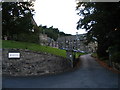
1
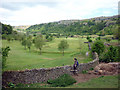
Giggleswick golf course
It's hard to tell from the map if the right of way enters the golf course or stays outside their boundary wall. We had differing versions from golfers and residents of the house overlooking the course (whose garden MAY be traversed by the public footpath although there are no signs of entry/exit stiles).
Image: © Karl and Ali
Taken: 31 May 2010
0.03 miles
2
Giggleswick School
Founded in 1512, Giggleswick School received its Royal Charter in 1553. In this century it has expanded to become one of the leading independent boarding and day schools in the North of England with a national and international reputation.
Image: © Chris Eccleston
Taken: 24 Aug 2005
0.07 miles
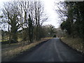
4
The footpath to Tarn Brow
No stile (on this wall or the one in the middle distance) and no waymarks. This was symptomatic of several public footpaths we walked (or tried to even) during our short ramble around Giggleswick. We don't think walkers are welcome here - NYCC have been notified.
Image: © Karl and Ali
Taken: 31 May 2010
0.13 miles
5

Some of us aren't looking at the stars
Interior view of the disused observatory above Giggleswick school showing the pedestal that must have held the telescope and the circular rail that the dome rotated upon. Judging by the amount of cans and bottles lying around some of the local "yoof" must be seeing a few stars.
Image: © Karl and Ali
Taken: 31 May 2010
0.15 miles
6
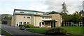
Catteral Hall Classroom block
Opened by Richard Whiteley and Carol Vorderman this building contains comfortable classrooms, the library with a wonderful picture window of Giggleswick Scar and quarry, and also the ICT suite.
Image: © William Bartlett
Taken: 3 Oct 2005
0.17 miles
7
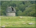
Disused observatory, Giggleswick
I thought this looked like an observatory, with the vertical slit in the roof for the telescope to look through. Presumably the roof can be rotated. Sure enough, it is captioned 'Observatory' on the large-scale OS map. There was a solar eclipse at Giggleswick in 1927, but it seems that it was observed from the playing fields rather than from this observatory.
Image: © Humphrey Bolton
Taken: 2 Aug 2009
0.19 miles
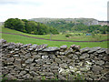
8
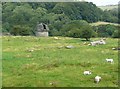
Field with observatory, Giggleswick
This gives context to Image A rocky field grazed by sheep.
Image: © Humphrey Bolton
Taken: 2 Aug 2009
0.19 miles
9
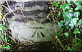
Benchmark on stone in B6480 wall near Giggleswick Quarry
Ordnance Survey cut mark benchmark described on the Bench Mark Database at http://www.bench-marks.org.uk/bm87768
Image: © Roger Templeman
Taken: 16 Aug 2017
0.20 miles
10
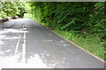
B6480 approaching Giggleswick Quarry
There is an OS benchmark Image on the stone in the roadside wall exposed by clearing ivy
Image: © Roger Templeman
Taken: 16 Aug 2017
0.20 miles