IMAGES TAKEN NEAR TO
Glenfield, SHIPLEY, BD18 1ER
Introduction
This page details the photographs taken nearby to Glenfield, BD18 1ER by members of the Geograph project.
The Geograph project started in 2005 with the aim of publishing, organising and preserving representative images for every square kilometre of Great Britain, Ireland and the Isle of Man.

There are currently over 7.5m images from over14,400 individuals and you can help contribute to the project by visiting https://www.geograph.org.uk
Image Map (Loading...)


Getting Data...Please wait
Leaflet Map data © OpenStreetMap
Images are licensed for reuse under creativecommons.org/licenses/by-sa/2.0
Notes
- Clicking on the map will re-center to the selected point.
- The higher the marker number, the further away the image location is from the centre of the postcode.
Image Listing (77 Images Found)
Images are licensed for reuse under creativecommons.org/licenses/by-sa/2.0
Image
Details
Distance
1
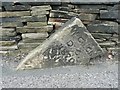
Boundary stone, Windhill Old Road Thackley
To the left of the stone it is Thackley Old Road, Windhill. The inscription is difficult to understand. W. a. a. / D. K. / 1870 / No. 3 (?). Both Thackley and Windhill were in the township and ecclesiastical parish of Idle, but in 1870 Windhill became a separate parish, and also an Urban Sanitary District in 1875. It became part of Shipley Urban District, so that the stone was on a local government boundary until 1974. The date 1870 and the number make it very likely that this was one of a series of stones marking the boundary of the newly created parish.
Image: © Humphrey Bolton
Taken: 24 Jul 2010
0.01 miles
2
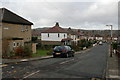
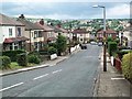
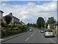
Glenfield, West Royd
Looking along Glenfield from its junction with Leeds Road.
Image: © Mark Anderson
Taken: 11 Nov 2008
0.01 miles
3
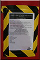
Change to collection times from this postbox
The collection times will be altered for this postbox: Image
Image: © Mark Anderson
Taken: 11 Nov 2008
0.03 miles
5
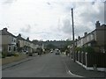
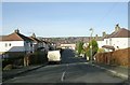
Glenfield
With view across the Aire Valley to Baildon
Image: © David Spencer
Taken: 6 Jul 2005
0.04 miles
6
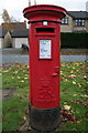
Elizabeth II Postbox, Leeds Road
At the junction with Glenfield. The tape on the side is a notice regarding a change to collection times: Image
Image: © Mark Anderson
Taken: 11 Nov 2008
0.04 miles
9
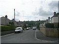
Thackley Old Road - viewed from Windhill Old Road
Image: © Betty Longbottom
Taken: 11 Jul 2011
0.06 miles
10
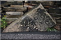
Old Boundary Marker in Shipley, north of Bradford
Ecclesiastical Boundary Marker by the UC road, in parish of Bradford (Bradford District), Thackley, junction of Thackley Old Road and Windhill Old Road, in road against stone wall and vulnerable to being hit, on North side of road.
Inscription reads:- : W Ch Ch D C / 1870 / No 3 :
Thanks for this information provided by Richard Heywood:
"Windhill Christ Church District Chapelry. This new church was established in 1870, hence the date, and the item in the London Gazette authorising it and defining the boundaries of the chapelry indicates that there were originally (and still could be) five such boundary stones, numbered 1-5."
Milestone Society National ID: YW_BRAD04pb
Image: © Milestone Society
Taken: Unknown
0.07 miles