IMAGES TAKEN NEAR TO
Gawthorpe Avenue, BINGLEY, BD16 4DG
Introduction
This page details the photographs taken nearby to Gawthorpe Avenue, BD16 4DG by members of the Geograph project.
The Geograph project started in 2005 with the aim of publishing, organising and preserving representative images for every square kilometre of Great Britain, Ireland and the Isle of Man.

There are currently over 7.5m images from over14,400 individuals and you can help contribute to the project by visiting https://www.geograph.org.uk
Image Map
Images are licensed for reuse under creativecommons.org/licenses/by-sa/2.0
Notes
- Clicking on the map will re-center to the selected point.
- The higher the marker number, the further away the image location is from the centre of the postcode.
Image Listing (227 Images Found)
Images are licensed for reuse under creativecommons.org/licenses/by-sa/2.0
Image
Details
Distance
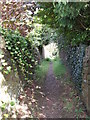
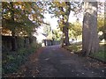
2
Spa Lane - viewed from near Gawthorpe Drive
Image: © Betty Longbottom
Taken: 26 Oct 2012
0.04 miles
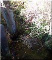
4
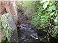
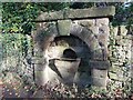
New Mill Gill at Gawthorpe
From a culvert beneath Gawthorpe Lane, the beck reappears to flow down over these sets. The large upright slab to the left looks like one side of a gap stile.
This is one of the few places where the beck's flow seems to be controlled in any way. Where the culvert emerges, it appears as if there is an older structure upon which the more modern one has been constructed.
Image: © John Davies
Taken: 17 Apr 2017
0.05 miles
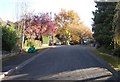
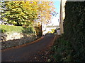
5
Gawthorpe Drive - viewed from near Spa Lane
Image: © Betty Longbottom
Taken: 26 Oct 2012
0.05 miles
8
Drinking Fountain - Spa Lane
This shows the initials T G and the date 1871.
Image: © Betty Longbottom
Taken: 26 Oct 2012
0.06 miles
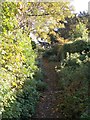
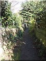
9
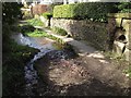
Spa Lane, Bingley
From Park Road, Spa Lane rapidly becomes a track.
A small stream runs parallel to the track before meeting a larger beck. The larger beck flows under the large stone slab in the centre. The flow continues alongside the path before dropping under the wall on the left.
This beck is the principal contributor to New Mill Gill, which flows under the bottom of 5 Rise Locks.
The drinking fountain on the right is labelled "spa" on the 1847-8 OS map. Presumably that is why the path is named Spa Lane. Nevertheless it seems a strange place to have a drinking fountain.
Image: © John Davies
Taken: 3 Apr 2017
0.07 miles