IMAGES TAKEN NEAR TO
Whalley Lane, BRADFORD, BD13 4LJ
Introduction
This page details the photographs taken nearby to Whalley Lane, BD13 4LJ by members of the Geograph project.
The Geograph project started in 2005 with the aim of publishing, organising and preserving representative images for every square kilometre of Great Britain, Ireland and the Isle of Man.

There are currently over 7.5m images from over14,400 individuals and you can help contribute to the project by visiting https://www.geograph.org.uk
Image Map
Images are licensed for reuse under creativecommons.org/licenses/by-sa/2.0
Notes
- Clicking on the map will re-center to the selected point.
- The higher the marker number, the further away the image location is from the centre of the postcode.
Image Listing (16 Images Found)
Images are licensed for reuse under creativecommons.org/licenses/by-sa/2.0
Image
Details
Distance
1
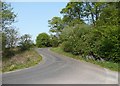
Double bend on Whalley Lane, Denholme
Image: © Humphrey Bolton
Taken: 21 Apr 2011
0.03 miles
2
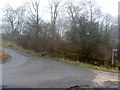
Start of the S bends on Whalley Lane, near Denholme
Image: © Steve Fareham
Taken: 6 Feb 2010
0.03 miles
3
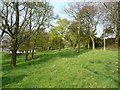
Wood pasture off Whalley Lane, Denholme
The trees are widely spaced so that a lush carpet of grass can grow.
Image: © Humphrey Bolton
Taken: 21 Apr 2011
0.06 miles
4
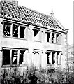
Hollin Park near Denholme
Farmhouse in state of dereliction
Image: © Alan Longbottom
Taken: Unknown
0.09 miles
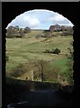
5
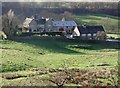
Hollin Park, Denholme
Large house in the Denholme Beck Valley north of Doe Park Reservoir, looking west-northwest from Cripple Croft Plantation near Thorngate on Whalley Lane.
Image: © Paul Glazzard
Taken: 6 Mar 2007
0.09 miles
6
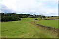
In the Valley created by Denholme Beck
The footpath follows to the left of the wall towards Whalley Lane
Image: © Chris Heaton
Taken: 13 Jul 2016
0.10 miles
7
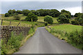
Whalley Lane
Climbing east out of the valley created by Denholme Beck
Image: © Chris Heaton
Taken: 13 Jul 2016
0.12 miles
8
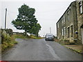
Road junction
The junction of Tewitt Lane and Ten Yards Lane
Image: © Alexander P Kapp
Taken: 21 Jul 2009
0.12 miles
9
Whalley Lane, Denholme
Looking east along Whalley Lane from the disused railway bridge near Buck Park, towards Meal Bridge in the Denhlome Beck valley and Old Allen Moor beyond.
Image: © Paul Glazzard
Taken: 6 Mar 2007
0.13 miles
10
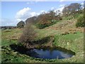
Cripple Croft Plantation, Denholme
Water-filled shaft at the old mine north of Doe Park Reservoir, looking north-northeast towards Thorngate and Cripple Croft Plantation.
Image: © Paul Glazzard
Taken: 6 Mar 2007
0.13 miles