IMAGES TAKEN NEAR TO
Brewery Lane, BRADFORD, BD13 1NG
Introduction
This page details the photographs taken nearby to Brewery Lane, BD13 1NG by members of the Geograph project.
The Geograph project started in 2005 with the aim of publishing, organising and preserving representative images for every square kilometre of Great Britain, Ireland and the Isle of Man.

There are currently over 7.5m images from over14,400 individuals and you can help contribute to the project by visiting https://www.geograph.org.uk
Image Map
Images are licensed for reuse under creativecommons.org/licenses/by-sa/2.0
Notes
- Clicking on the map will re-center to the selected point.
- The higher the marker number, the further away the image location is from the centre of the postcode.
Image Listing (23 Images Found)
Images are licensed for reuse under creativecommons.org/licenses/by-sa/2.0
Image
Details
Distance
2
Ashgrove, West Scholes from Cow Lane
Image: © Michael Steele
Taken: 18 Sep 2009
0.09 miles
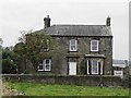
4
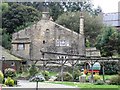
Brewery Lane, West Scholes
Cottages by the mill on Brewery Lane in the village of West Scholes, north of Queensbury. The plaque above the door in the centre reads "VHIH 1694".
Image: © Paul Glazzard
Taken: 6 Mar 2007
0.13 miles
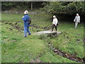
6
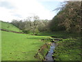
Footbridge over High Birks Beck, West Scholes
Image: © John Slater
Taken: 24 Apr 2014
0.15 miles
7
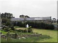
Northlight extension to Former Clayton Brewery
This extension dates from the 1920s when the premises were first used as a Textile Mill producing Moquette.
Image: © Michael Steele
Taken: 18 Sep 2009
0.16 miles
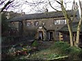
9
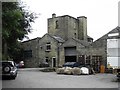
The Former Clayton Brewery, Brewery Lane, West Scholes
Image: © Michael Steele
Taken: 18 Sep 2009
0.16 miles
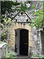
10
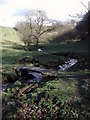
High Birks Beck, Upper Headley
Footbridge across High Birks Beck between Thornton and Queensbury. Beyond the trees the valley is blocked by an embankment built for the railway line, which is now disused.
Image: © Paul Glazzard
Taken: 6 Mar 2007
0.17 miles