IMAGES TAKEN NEAR TO
Harrogate Road, BRADFORD, BD10 0RA
Introduction
This page details the photographs taken nearby to Harrogate Road, BD10 0RA by members of the Geograph project.
The Geograph project started in 2005 with the aim of publishing, organising and preserving representative images for every square kilometre of Great Britain, Ireland and the Isle of Man.

There are currently over 7.5m images from over14,400 individuals and you can help contribute to the project by visiting https://www.geograph.org.uk
Image Map
Images are licensed for reuse under creativecommons.org/licenses/by-sa/2.0
Notes
- Clicking on the map will re-center to the selected point.
- The higher the marker number, the further away the image location is from the centre of the postcode.
Image Listing (139 Images Found)
Images are licensed for reuse under creativecommons.org/licenses/by-sa/2.0
Image
Details
Distance
2
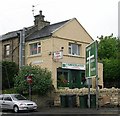
Greengates Fisheries - Harrogate Road
Image: © Betty Longbottom
Taken: 16 May 2007
0.01 miles
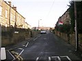
3
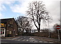
Stockhill Road, Greengates
Behind the wall on the right is the roof of the new Greengates Primary School. Note the prominent "No Entry" signage at the end of the road.
Image: © Linden Milner
Taken: 21 Feb 2014
0.02 miles
4
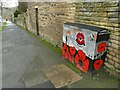
Remembrance box, Harrogate Road, Greengates
Painting utility cabinets in abstract or decorative designs has become a fashion in the last few years. This is the first I've seen on the theme of wartime remembrance. The text on the end reads "Commissioned by Friends of Greengates cenotaph. Bradford Street Art box 1 @bdstreetart". The last bit looks like a 'Twitter handle' but isn't. The group does however have a Facebook page showing several designs in the area. For the cenotaph, see Image
Image: © Stephen Craven
Taken: 11 Jan 2022
0.03 miles
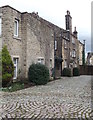
5
Snowdrops in front garden of Greengates House
Image: © Linden Milner
Taken: 22 Feb 2014
0.03 miles
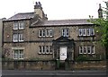
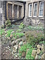
7
The back of "Greengates House", now offices
This is a view of the path at the back of Greengates House (now offices) which stands just below the crossroads. Some old cobbled "setts" have presumably been relaid to form a decorative feature.
Image: © Linden Milner
Taken: 21 Feb 2014
0.04 miles
8
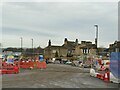
Roadworks at Greengates junction
The junction of New Line (A657) and Harrogate Road (A658) is being remodelled. Work has been going on for well over a year already and is nowhere near finished, and locals are getting rather annoyed about the delays, as the temporary 4-way traffic lights are increasing the congestion that the works are designed to ease.
This view is looking along the new slip road that will avoid the traffic lights for traffic from Yeadon towards Calverley, but that only forms a small proportion of the throughput of the junction. How much it will actually reduce congestion is a moot point, but presumably traffic modelling has produced a positive cost-benefit ratio.
Image: © Stephen Craven
Taken: 11 Jan 2022
0.04 miles
9
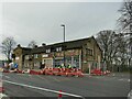
Roadworks, Harrogate Road, Greengates
The junction of New Line (A657) and Harrogate Road (A658) is being remodelled. Work has been going on for well over a year already and is nowhere near finished, and locals are getting rather annoyed about the delays, as the temporary 4-way traffic lights are increasing the congestion that the works are designed to ease.
The building in the background is the former Seven Stars pub, now a row of shops. It is listed grade II (list entry 1133123) where it is dated to circa 1830-40, "rebuild of earlier inn or former building".
Image: © Stephen Craven
Taken: 11 Jan 2022
0.04 miles
10
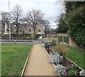
Greengates Community Garden looking towards the war memorial
This is another view of Greengates Community Garden, looking towards the war memorial and the building belonging to QRI Ltd. which was previously the old village school.
Image: © Linden Milner
Taken: 21 Feb 2014
0.04 miles