IMAGES TAKEN NEAR TO
Stoberry Park, WELLS, BA5 3LD
Introduction
This page details the photographs taken nearby to Stoberry Park, BA5 3LD by members of the Geograph project.
The Geograph project started in 2005 with the aim of publishing, organising and preserving representative images for every square kilometre of Great Britain, Ireland and the Isle of Man.

There are currently over 7.5m images from over14,400 individuals and you can help contribute to the project by visiting https://www.geograph.org.uk
Image Map
Images are licensed for reuse under creativecommons.org/licenses/by-sa/2.0
Notes
- Clicking on the map will re-center to the selected point.
- The higher the marker number, the further away the image location is from the centre of the postcode.
Image Listing (9 Images Found)
Images are licensed for reuse under creativecommons.org/licenses/by-sa/2.0
Image
Details
Distance
1
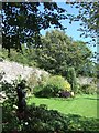
In the walled garden of Stoberry Park
The walls of this garden are built of stone, in contrast to those of many estates where brick is used.
Image: © David Smith
Taken: 28 Sep 2011
0.04 miles
3
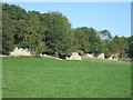
The woods of Stoberry Warren, with stone wall on the south side
Image: © David Smith
Taken: 28 Sep 2011
0.11 miles
4
A38 entering The City of Wells
The City of Wells dates back to Roman times.
Image: © J.Hannan-Briggs
Taken: 31 Jul 2014
0.14 miles
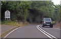
5
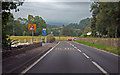
Descending Bristol Hill, A39
There is an escape lane some 400 yards ahead.
Near Beryl Farm.
Image: © J.Hannan-Briggs
Taken: 31 Jul 2014
0.18 miles
6
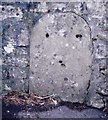
Old Milestone, A39, Bath Hill, East of Walcombe
The milestone is located about half a mile north from the junction with Walcombe Lane, in the wall beside the pavement on the south side of road. Parish of St Cuthbert Out (Mendip District). Stone post (plate lost), erected by the Wells turnpike trust in the 19th century.
Inscription once read:- : (Bath 19⅞ / Wells 1) :
Milestone Society National ID: SO_BWWL21
Image: © JR Dowding
Taken: 9 Jan 2008
0.19 miles
8
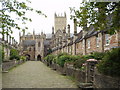
Vicars Close, Wells, Somerset
Looking south, the tower of Wells Cathedral clearly seen beyond the Close.
Image: © Clive Barry
Taken: 22 Jul 2003
0.21 miles
9
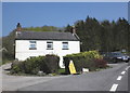
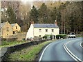
Cottage, near Walcombe, on Bristol Hill
Image: © Roger Cornfoot
Taken: 23 Apr 2010
0.23 miles