IMAGES TAKEN NEAR TO
Manning Close, WELLS, BA5 2XT
Introduction
This page details the photographs taken nearby to Manning Close, BA5 2XT by members of the Geograph project.
The Geograph project started in 2005 with the aim of publishing, organising and preserving representative images for every square kilometre of Great Britain, Ireland and the Isle of Man.

There are currently over 7.5m images from over14,400 individuals and you can help contribute to the project by visiting https://www.geograph.org.uk
Image Map
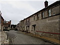
Images are licensed for reuse under creativecommons.org/licenses/by-sa/2.0
Notes
- Clicking on the map will re-center to the selected point.
- The higher the marker number, the further away the image location is from the centre of the postcode.
Image Listing (77 Images Found)
Images are licensed for reuse under creativecommons.org/licenses/by-sa/2.0
Image
Details
Distance
1
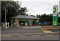
Car wash, Bath Road, Wells
Set back from the south side of Bath Road, the car wash is part of the Budgens and BP filling station site. http://www.geograph.org.uk/photo/5139304
Image: © Jaggery
Taken: 27 Sep 2016
0.03 miles
2
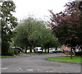
Woodbury Avenue, Wells
Woodbury Avenue descends from the south side of Bath Road.
Image: © Jaggery
Taken: 27 Sep 2016
0.04 miles
3
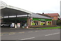
Budgens, Wells
Budgens minimarket and post office viewed across Bath Road.
Image: © Jaggery
Taken: 27 Sep 2016
0.04 miles
4
Budgens minimarket and BP filling station, Wells
Viewed across Bath Road.
Image: © Jaggery
Taken: 27 Sep 2016
0.04 miles
5
Plaque recording the naming of Paray Drive, Wells
The plaque is on a boulder on the corner of Bath Road and Hawker's Lane.
Image: © Jaggery
Taken: 27 Sep 2016
0.05 miles
6
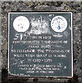
Paray Drive naming plaque detail, Wells
Located here, http://www.geograph.org.uk/photo/5139267 the plaque records that nearby Paray Drive http://www.geograph.org.uk/photo/5139255 was named to celebrate the twinning of Wells with Paray Le Monial.
Image: © Jaggery
Taken: 27 Sep 2016
0.05 miles
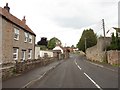
8
Western end of Bath Road, Wells
The B3139 St Thomas Street behind the camera is the B3139 Bath Road ahead.
Image: © Jaggery
Taken: 27 Sep 2016
0.06 miles
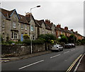
9
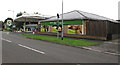
West side of The Mews, Bath Road, Wells
21st century housing set back from the south side of Bath Road.
A nameplate behind the camera shows THE MEWS/AD 2012/Private Road.
Image: © Jaggery
Taken: 27 Sep 2016
0.07 miles
10

East side of The Mews, Bath Road, Wells
21st century housing set back from the south side of Bath Road.
The nameplate on the left shows THE MEWS/AD 2012/Private Road.
Image: © Jaggery
Taken: 27 Sep 2016
0.07 miles