IMAGES TAKEN NEAR TO
Silver Street, RADSTOCK, BA3 5SU
Introduction
This page details the photographs taken nearby to Silver Street, BA3 5SU by members of the Geograph project.
The Geograph project started in 2005 with the aim of publishing, organising and preserving representative images for every square kilometre of Great Britain, Ireland and the Isle of Man.

There are currently over 7.5m images from over14,400 individuals and you can help contribute to the project by visiting https://www.geograph.org.uk
Image Map
Images are licensed for reuse under creativecommons.org/licenses/by-sa/2.0
Notes
- Clicking on the map will re-center to the selected point.
- The higher the marker number, the further away the image location is from the centre of the postcode.
Image Listing (41 Images Found)
Images are licensed for reuse under creativecommons.org/licenses/by-sa/2.0
Image
Details
Distance
1
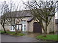
Kilmersdon village hall
Built in 1992 this hall offers a good range of services and facilities. Many events are held here, including most recently the 2013 Wassail.
Image: © Neil Owen
Taken: 11 Feb 2013
0.06 miles
2
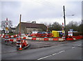
New roads, new houses
The entrance to Kilmersdon village hall is currently in the process of some new building work, with some residential properties under construction to the left of shot. See Image] for the hall.
Image: © Neil Owen
Taken: 11 Feb 2013
0.07 miles
3
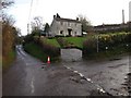
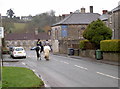
Lane junction, Kilmersdon
Silver Street passes a side turning to Walton Farm. As the sign indicates, this leads to a bridleway, FR 7/17, which climbs the Kilmersdon Brook valley towards Lipyeate.
Image: © Derek Harper
Taken: 26 Nov 2009
0.08 miles
4
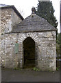
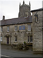
The old Blind House - lock up
A plaque reads thus:
'The Blind House - Lock Up
Originally built by the churchyard wall as a guardhouse in 1785, rebuilt in its present position in 1835 on the site of the parish stocks. Restored by the parish council in 1992.'
It also appears to be used as a bus shelter too.
Image: © Neil Owen
Taken: 11 Feb 2013
0.09 miles
5
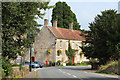
Rural gridlock?
Kilmersdon remains a quiet little village, despite the heavy traffic clogging the roads.
Image: © Neil Owen
Taken: 11 Feb 2013
0.10 miles
6
It wouldn't be a village
If it didn't have a church and a pub! The Jolliffe Arms, in close proximity to St Peter and St Paul.
Image: © Neil Owen
Taken: 11 Feb 2013
0.11 miles
7
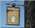
2009 : Sign outside the Jolliffe Arms, Kilmersdon
The motto 'Tant que je puis', is Old French, and means 'As much as I can'.
A brief search of the internet revealed a totally different coat of arms for the Jolliffe family.
Image: © Maurice Pullin
Taken: 15 Nov 2009
0.11 miles
8
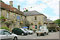
2008 : Joliffe Arms, Kilmersdon
In the 19th century Kilmersdon was a mining village. It was also surrounded by stone quarries.
For photos of Kilmersdon in the 1950/60s see http://www.francisfrith.co.uk/search/england/avon/kilmersdon/photos/kilmersdon_photos.htm
Image: © Maurice Pullin
Taken: 17 Jun 2008
0.12 miles
9
235 & 236 Kilmersdon Hill
Grade II* listed https://historicengland.org.uk/listing/the-list/list-entry/1058660
Image: © Oast House Archive
Taken: 25 Aug 2013
0.13 miles
10
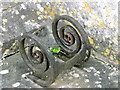
Detail, Church of St Peter and St Paul
The boot scraper is set beside the west door. For a wider view Image
These metal objects are prized by antique dealers, revered by history buffs, but are an object of puzzlement to many a 21st century pedestrian.
Image: © Maigheach-gheal
Taken: 31 Aug 2011
0.13 miles