IMAGES TAKEN NEAR TO
Wells Road, RADSTOCK, BA3 3XU
Introduction
This page details the photographs taken nearby to Wells Road, BA3 3XU by members of the Geograph project.
The Geograph project started in 2005 with the aim of publishing, organising and preserving representative images for every square kilometre of Great Britain, Ireland and the Isle of Man.

There are currently over 7.5m images from over14,400 individuals and you can help contribute to the project by visiting https://www.geograph.org.uk
Image Map
Images are licensed for reuse under creativecommons.org/licenses/by-sa/2.0
Notes
- Clicking on the map will re-center to the selected point.
- The higher the marker number, the further away the image location is from the centre of the postcode.
Image Listing (5 Images Found)
Images are licensed for reuse under creativecommons.org/licenses/by-sa/2.0
Image
Details
Distance

2
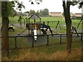
Playground, Fosse Way
At the southern corner of the recreation ground seen in the background.
Image: © Derek Harper
Taken: 7 Oct 2009
0.18 miles
3

Pillbox at Inner Elm Terrace
A view looking to the southwest towards a pillbox at the western end of Inner Elm Terrace. The remains of two 'dragons teeth' can be seen on the left of the lane. These wartime relics formed part of the defensive perimeter of Norton Hill Colliery.
Image: © Phil Williams
Taken: 7 Jun 2007
0.20 miles
4

Pillbox at Inner Elm Terrace
A view looking to the west towards a pillbox at the western end of Inner Elm Terrace. Until recently, this was largely covered by an overgrowth of brambles. The right-hand wall of the box is still blackened by the fire that removed the overgrowth. This box formed part of the defensive perimeter for Norton Hill Colliery.
Image: © Phil Williams
Taken: 7 Jun 2007
0.20 miles
5
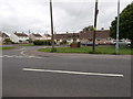
The way to Poets' Corner
The street which runs parallel to the main A367 Wells Road is Wesley Road, doubtless named for the nearby Methodist church. Beyond it are Wesley Avenue as well as Shakespeare Road, Milton Road and Ruskin Road.
Image: © HelenK
Taken: 31 May 2017
0.23 miles