IMAGES TAKEN NEAR TO
Wells Road, RADSTOCK, BA3 3SB
Introduction
This page details the photographs taken nearby to Wells Road, BA3 3SB by members of the Geograph project.
The Geograph project started in 2005 with the aim of publishing, organising and preserving representative images for every square kilometre of Great Britain, Ireland and the Isle of Man.

There are currently over 7.5m images from over14,400 individuals and you can help contribute to the project by visiting https://www.geograph.org.uk
Image Map
Images are licensed for reuse under creativecommons.org/licenses/by-sa/2.0
Notes
- Clicking on the map will re-center to the selected point.
- The higher the marker number, the further away the image location is from the centre of the postcode.
Image Listing (14 Images Found)
Images are licensed for reuse under creativecommons.org/licenses/by-sa/2.0
Image
Details
Distance
1
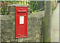
2009 : George V wall postbox, Radstock
On Wells Road.
Image: © Maurice Pullin
Taken: 10 Aug 2009
0.03 miles
2
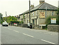
2009 : Chish and Fips Take Away, Wells Road
Didn't say if they supplied valt and sinegar.
Technical note: this is the A367 leading into the Fosse Way further along then on to Wells.
Image: © Maurice Pullin
Taken: 10 Aug 2009
0.03 miles
4
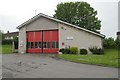
Radstock Fire Station
Radstock Fire Station, Wells Road, Radstock is part of the Avon Fire & Rescue Service, and it situated next to the Police Station.
Image: © Kevin Hale
Taken: 28 May 2006
0.11 miles
5
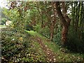
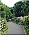
Path at Radstock
The path drops through a triangle of woodland on the slope between Welton Road (left) and Somervale Road (the A362), just discernible through the trees.
Image: © Derek Harper
Taken: 7 Oct 2009
0.14 miles
6
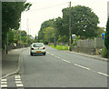
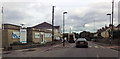
2009 : A367 Wells Road, Radstock (2)
Image: © Maurice Pullin
Taken: 10 Aug 2009
0.16 miles
7
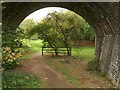
One of the Five Arches
Looking beneath an arch of the Five Arches Viaduct which carried the former Somerset & Dorset Joint Railway across the former Great Western Railway’s North Somerset branch line, which is now a cyclepath, and from which this is taken. The viaduct has been recreated by Egham & Staines Model Railway Society http://www.egham-staines-mrs.co.uk/layout_5arch.htm .
Image: © Derek Harper
Taken: 7 Oct 2009
0.18 miles
8
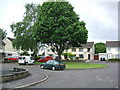
Highfields, off Wells Road, Radstock
Image: © Nigel Shoosmith
Taken: 12 May 2007
0.18 miles
9
Crossing Point
View from part of the cycle path between Midsomer Norton and Radstock, B & N E S.
Of the crossing point at Welton Hollow, on the A362 Somervale Road/ Radstock Road.
Where the fifth arch of the famous SDJR 'Five Arch' railway viaduct was located.
The slope down to the road is copied by a slope up in trees on the other side.
Cycle path runs parallel at times on former SDJR Radstock-Midsomer Norton section.
Image: © D M Wilmot
Taken: 2 Aug 2018
0.19 miles
10
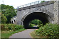
Former railway flyover
Known as Five Arches, only four are visible here. The fifth, to the right of this image, is partially blocked. The flyover carried the Somerset and Dorset Joint Railway over the Great Western Railway. Both routes are now cycle tracks.
Image: © David Martin
Taken: 2 Aug 2018
0.19 miles