IMAGES TAKEN NEAR TO
Briar Close, RADSTOCK, BA3 3EL
Introduction
This page details the photographs taken nearby to Briar Close, BA3 3EL by members of the Geograph project.
The Geograph project started in 2005 with the aim of publishing, organising and preserving representative images for every square kilometre of Great Britain, Ireland and the Isle of Man.

There are currently over 7.5m images from over14,400 individuals and you can help contribute to the project by visiting https://www.geograph.org.uk
Image Map
Images are licensed for reuse under creativecommons.org/licenses/by-sa/2.0
Notes
- Clicking on the map will re-center to the selected point.
- The higher the marker number, the further away the image location is from the centre of the postcode.
Image Listing (3 Images Found)
Images are licensed for reuse under creativecommons.org/licenses/by-sa/2.0
Image
Details
Distance
1
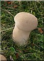
Fungus near Haydon
This common puffball is on the north side of the colliery waste tip shown in Image
Image: © Derek Harper
Taken: 26 Nov 2009
0.11 miles
2

Coal tip in Waterside valley
A reverse view of Image, looking down from near the summit of the black shale waste heap. The stream passes directly underneath the tip.
Image: © Derek Harper
Taken: 26 Nov 2009
0.18 miles
3

Stream at site of Kilmersdon Colliery tip
Footpath FR 7/11 drops to cross a swollen tributary of the Waterside brook, with the remains of a coal batch on the right, left over from Kilmersdon Colliery which closed in 1973.
Image: © Derek Harper
Taken: 26 Nov 2009
0.21 miles