IMAGES TAKEN NEAR TO
Wheelers Road, RADSTOCK, BA3 2BX
Introduction
This page details the photographs taken nearby to Wheelers Road, BA3 2BX by members of the Geograph project.
The Geograph project started in 2005 with the aim of publishing, organising and preserving representative images for every square kilometre of Great Britain, Ireland and the Isle of Man.

There are currently over 7.5m images from over14,400 individuals and you can help contribute to the project by visiting https://www.geograph.org.uk
Image Map (Loading...)


Getting Data...Please wait
Leaflet Map data © OpenStreetMap
Images are licensed for reuse under creativecommons.org/licenses/by-sa/2.0
Notes
- Clicking on the map will re-center to the selected point.
- The higher the marker number, the further away the image location is from the centre of the postcode.
Image Listing (12 Images Found)
Images are licensed for reuse under creativecommons.org/licenses/by-sa/2.0
Image
Details
Distance
1
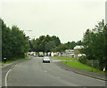
2009 : A362 Radstock Road
Heading into Midsomer Norton.
If you turn round here you find yourself in Somervale Road heading into Radstock. (note - two separate places)
Image: © Maurice Pullin
Taken: 10 Aug 2009
0.12 miles
2
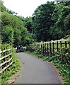
Crossing Point
View from part of the cycle path between Midsomer Norton and Radstock, B & N E S.
Of the crossing point at Welton Hollow, on the A362 Somervale Road/ Radstock Road.
Where the fifth arch of the famous SDJR 'Five Arch' railway viaduct was located.
The slope down to the road is copied by a slope up in trees on the other side.
Cycle path runs parallel at times on former SDJR Radstock-Midsomer Norton section.
Image: © D M Wilmot
Taken: 2 Aug 2018
0.12 miles
3

View across to Wheeler's Hill
From the former railway line between Radstock and Midsomer Norton South.
Image: © David Martin
Taken: 2 Aug 2018
0.12 miles
4
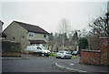
Highfields, off Wells Road, Radstock
Image: © Nigel Shoosmith
Taken: 12 May 2007
0.14 miles
5
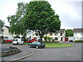
Wheelers Road, Midsomer Norton
Image: © Dominic Dawn Harry and Jacob Paterson
Taken: 19 Feb 2006
0.15 miles
6
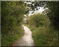
Norton Radstock Greenway
This cycleway follows the track of the Bristol and North Somerset Railway, which operated between 1873 and 1968.
Image: © Derek Harper
Taken: 7 Oct 2009
0.19 miles
7
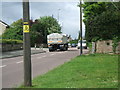
A367 Wells Road, Radstock
The main road through Westfield, Radstock. Picture taken at the junction withs Highfields. Lorry is passing junction with Westhill Road.
Image: © Nigel Shoosmith
Taken: 12 May 2007
0.21 miles
8
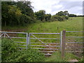
Field gate on The Fosse Way byway
The Byway passes through this articulated gate (you can open just half for horses or all of the gate for larger vehicles) before it crosses the Norton Radstock Greenway bike path. There are bollards on the Greenway path to prevent vehicles leaving the byway. The byway is then tarmac up to its junction with the A362.
Image: © James Ayres
Taken: 18 Aug 2012
0.21 miles
9
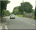
2009 : A367 Wells Road, Radstock (2)
Image: © Maurice Pullin
Taken: 10 Aug 2009
0.23 miles
