IMAGES TAKEN NEAR TO
Shoscombe, BATH, BA2 8LX
Introduction
This page details the photographs taken nearby to BA2 8LX by members of the Geograph project.
The Geograph project started in 2005 with the aim of publishing, organising and preserving representative images for every square kilometre of Great Britain, Ireland and the Isle of Man.

There are currently over 7.5m images from over14,400 individuals and you can help contribute to the project by visiting https://www.geograph.org.uk
Image Map
Images are licensed for reuse under creativecommons.org/licenses/by-sa/2.0
Notes
- Clicking on the map will re-center to the selected point.
- The higher the marker number, the further away the image location is from the centre of the postcode.
Image Listing (11 Images Found)
Images are licensed for reuse under creativecommons.org/licenses/by-sa/2.0
Image
Details
Distance
1
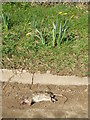
Wreath for a roadkill rodent
A rat has come to the end of its road.
Image: © Neil Owen
Taken: 26 Feb 2021
0.02 miles
2
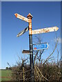
Signpost at Hang Hill
The signpost stands at the junction with the grassy Brinscombe Lane.
Image: © Neil Owen
Taken: 26 Feb 2021
0.03 miles
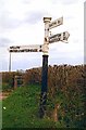
3
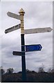
Old Direction Sign - Signpost by White Hill, Shoscombe
Pyramid finial - 3 arms; Somerset SCC pyramid by the UC road, in parish of Shoscombe (Bath and North East Somerset District), Hang Hill, junction with White Hill.
Surveyed
Milestone Society National ID: SO_ST7156A
Image: © Milestone Society
Taken: Unknown
0.03 miles
4

Old Direction Sign - Signpost by Whitehill, Shoscombe parish
Pyramid finial - 2 arms; Somerset SCC pyramid by the UC road, in parish of Shoscombe (Bath And North East Somerset District), White Hill junction with Barn Hill.
Surveyed
Milestone Society National ID: SO_ST7156B
Image: © Milestone Society
Taken: Unknown
0.03 miles
5

A mark on a barn on Barn Hill
White Hill can be approached from Barn Hill, the road from Single Hill. At the junction with the road named White Hill there is a small, covered and all but unrecognisable reservoir. Close by is a residential building which seems to have been a farm barn or such. A cut benchmark was made on its wall in the nineteenth century, slightly obscured by vegetation. See https://www.bench-marks.org.uk/bm142372 for the entry in the Benchmark Database or Image] for a wider view.
Image: © Neil Owen
Taken: 26 Feb 2021
0.04 miles
6

The top of Barn Hill
A barn, now apparently a residential building, at the junction with White Hill. An old benchmark can just about be found hiding behind a thick shrub trunk - see Image
Image: © Neil Owen
Taken: 26 Feb 2021
0.04 miles
7
Near Whitehill Cottages
Field near Whitehill Cottages.
Image: © Wayland Smith
Taken: 2 Apr 2021
0.10 miles
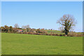
8
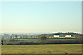
2008 : Fields near Peasedown St. John
Looking south toward Shoscombe from the minor road between Peasedown and Wellow.
Image: © Maurice Pullin
Taken: 9 Feb 2008
0.19 miles
9
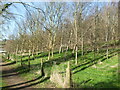
The Cinder Path
Running up from Shoscombe Vale to Shoscombe is the Cinder Path, an old footpath (BA23/12). As it approaches Shoscombe the land beside it has been given over to a large tree plantation.
Image: © Neil Owen
Taken: 26 Feb 2021
0.23 miles
10
Old Direction Sign - Signpost by Wellow Road, Shoscombe Parish
Pyramid finial - 4 arms; Somerset SCC pyramid by the UC road, in parish of Shoscombe (Bath and North East Somerset District), Hang Hill junction with Wellow Road.
Surveyed
Milestone Society National ID: SO_ST7156
Image: © J Dowding
Taken: Unknown
0.23 miles