IMAGES TAKEN NEAR TO
Shoscombe, BATH, BA2 8LP
Introduction
This page details the photographs taken nearby to BA2 8LP by members of the Geograph project.
The Geograph project started in 2005 with the aim of publishing, organising and preserving representative images for every square kilometre of Great Britain, Ireland and the Isle of Man.

There are currently over 7.5m images from over14,400 individuals and you can help contribute to the project by visiting https://www.geograph.org.uk
Image Map
Images are licensed for reuse under creativecommons.org/licenses/by-sa/2.0
Notes
- Clicking on the map will re-center to the selected point.
- The higher the marker number, the further away the image location is from the centre of the postcode.
Image Listing (14 Images Found)
Images are licensed for reuse under creativecommons.org/licenses/by-sa/2.0
Image
Details
Distance
1

Shoscombe Farmhouse
The "early C19" farm in lias limestone, is the last house in the village on Rag Hill, which climbs out westwards. Architectural details are at http://www.imagesofengland.org.uk/Details/Default.aspx?id=32663&mode=adv .
Image: © Derek Harper
Taken: 25 Feb 2009
0.07 miles
2
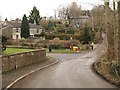
Green Street
Looking down the hill towards Shoscombe.
Image: © Wayland Smith
Taken: 2 Apr 2021
0.12 miles
3
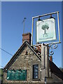
Making a home at the Apple Tree
The pub in Shoscombe has some attractive features: the gap in the eaves allow sparrows to start nesting.
Image: © Neil Owen
Taken: 26 Feb 2021
0.12 miles
4
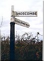
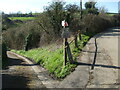
Direction Sign - Signpost on Rag Hill, Shoscombe
Lost finial - 2 arms; Somerset SCC pyramid by the UC road, in parish of Shoscombe (Bath And North East Somerset District), on the east side of the T junction of Green Street and Rag Hill.
surveyed
Milestone Society National ID: SO_ST7056
Image: © Milestone Society
Taken: Unknown
0.13 miles
5
The Apple Tree Inn, Shoscombe
A view looking to the west towards the Apple Tree Inn at Shoscombe.
Image: © Phil Williams
Taken: 9 Mar 2007
0.14 miles
6
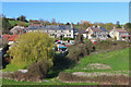
Shoscombe
A view looking to the northeast towards the village of Shoscombe, from the lane leading down to Shoscombe Vale.
Image: © Phil Williams
Taken: 9 Mar 2007
0.15 miles
7
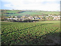
View over Shoscombe
Looking across the field towards Shoscombe.
Image: © Wayland Smith
Taken: 2 Apr 2021
0.16 miles
8
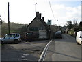
Where White Hill becomes Rag Hill
This junction features a third road, although it's a short one to Lower Shoscombe Farm and the cottages. Care needs to be taken not to fall foul of the sharp drop at the hairpin.
Image: © Neil Owen
Taken: 26 Feb 2021
0.19 miles
9
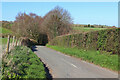
Shoscombe
The lane at the eastern end of the village, where it crosses a small valley and climbs White Hill.
Image: © Derek Harper
Taken: 25 Feb 2009
0.19 miles
10
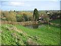
Flooded meadow at Shoscombe
A view looking to the southeast towards a flooded meadow, from the parking area of the Apple Tree Inn at Shoscombe.
Image: © Phil Williams
Taken: 9 Mar 2007
0.19 miles