IMAGES TAKEN NEAR TO
Dunkerton, BATH, BA2 8BX
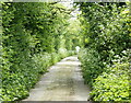
Introduction
This page details the photographs taken nearby to BA2 8BX by members of the Geograph project.
The Geograph project started in 2005 with the aim of publishing, organising and preserving representative images for every square kilometre of Great Britain, Ireland and the Isle of Man.

There are currently over 7.5m images from over14,400 individuals and you can help contribute to the project by visiting https://www.geograph.org.uk
Image Map
Images are licensed for reuse under creativecommons.org/licenses/by-sa/2.0
Notes
- Clicking on the map will re-center to the selected point.
- The higher the marker number, the further away the image location is from the centre of the postcode.
Image Listing (22 Images Found)
Images are licensed for reuse under creativecommons.org/licenses/by-sa/2.0
Image
Details
Distance
1
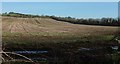
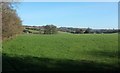
Arable field by the Fosse Way
The tree-lined Fosse, here a byway runs along the right side of the field, joining the A367 up the hill.
Image: © Derek Harper
Taken: 16 Feb 2016
0.05 miles
2
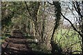
Fosse Way near Crossways Farm
Following the old track between trees on its way from Exeter to Lincoln.
Image: © Derek Harper
Taken: 16 Feb 2016
0.08 miles
3
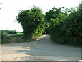
Junction on The Fosseway
The Fosseway Byway crosses a minor road at ST 721 603 and continues with a tarmac surface for a few hundred yards after which it reverts to being a dirt track.
Image: © James Ayres
Taken: 27 Jun 2010
0.08 miles
4
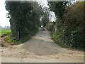
The Fosse Way carries on
The Fosse Way Roman road is little more than a dirt track at Crossways Farm. It is crossed by a modern tarmac road here but continues on to Dunkerton.
Image: © Neil Owen
Taken: 8 Mar 2021
0.08 miles
5
Field by the Fosse Way
The Fosse Way follows a byway through the trees on the left. This view is from where it crosses the road between Combe Hay and Inglesbatch, near Crossways Farm.
Image: © Derek Harper
Taken: 16 Feb 2016
0.10 miles
6
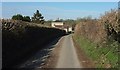
Approaching Crossways House
The lane from Crossways Farm approaches the former inn https://www.historicengland.org.uk/listing/the-list/list-entry/1129517 on the A367.
Image: © Derek Harper
Taken: 16 Feb 2016
0.11 miles
7
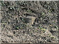
Old Boundary Marker on the A367
Turnpike Parish Boundary Marker on east side of the A367 just south of a static caravan site and the junction with the B3115. Formerly on the boundary of Englishcombe and Dunkerton parishes but now entirely in Dunkerton and Tunley parish. In raised lettering ENGLISHCOMBE on the left face, DUNKERTON on the right face, (BATH TURNPIK)E TRUST perpendicularly on the front face with 1827 above this. The top of the marker has been broken off and now lies flat on top and a chunk of it lies on the ground to the right. Grade II Listed details https://historicengland.org.uk/listing/the-list/list-entry/1129446.
Milestone Society National ID: SO_BARA03apb
Image: © Roadside Relics
Taken: 2 Mar 2023
0.13 miles
8
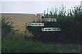
Direction Sign - Signpost by the A367, Englishcombe parish
Lost finial - 4 arms; Somerset SCC pyramid by the A367, in parish of Englishcombe (Bath and North East Somerset District), near Crossways Caravan Park on the east side of crossroads of the A367 and the lane to Combe Hay.
Surveyed
Milestone Society National ID: SO_ST7160
Image: © E Prideaux
Taken: Unknown
0.14 miles
9
2008 : The Fosse Way near Dunkerton
Looking south as it approaches Dunkerton and Peasedown St.John.
Image: © Maurice Pullin
Taken: 10 May 2008
0.14 miles
10
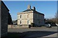
Crossways House
The former Crossways Inn https://www.historicengland.org.uk/listing/the-list/list-entry/1129517 at a crossroads on the A367. It's possible that the building to the left of the camera is the stable referred to at http://www.bathnes.gov.uk/sites/default/files/world_heritage_site_setting_study_rev4_current_22-10-09_web_version_part_3.pdf as "a stable near the summit of the hill, opposite the former Crossways Inn, which until the 20th century provided
trace horses to assist with heavy loads in the ascent" (ie from the Cam brook valley on the Wells to Bath road). The Elizabeth II postbox is number BA2 113.
Image: © Derek Harper
Taken: 16 Feb 2016
0.14 miles