IMAGES TAKEN NEAR TO
Dunkerton, BATH, BA2 8BB
Introduction
This page details the photographs taken nearby to BA2 8BB by members of the Geograph project.
The Geograph project started in 2005 with the aim of publishing, organising and preserving representative images for every square kilometre of Great Britain, Ireland and the Isle of Man.

There are currently over 7.5m images from over14,400 individuals and you can help contribute to the project by visiting https://www.geograph.org.uk
Image Map
Images are licensed for reuse under creativecommons.org/licenses/by-sa/2.0
Notes
- Clicking on the map will re-center to the selected point.
- The higher the marker number, the further away the image location is from the centre of the postcode.
Image Listing (20 Images Found)
Images are licensed for reuse under creativecommons.org/licenses/by-sa/2.0
Image
Details
Distance
1
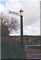
Old Direction Sign - Signpost by the B3115, Tunley Road, Dunkerton Parish
Pyramid finial - 1 arm; Somerset SCC pyramid by the B3115, in parish of Dunkerton (Bath and North East Somerset District), Tunley Road junction with lane to Priston.
Surveyed
Milestone Society National ID: SO_ST7059.
Image: © Milestone Society
Taken: Unknown
0.02 miles
2
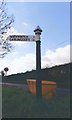
Old Direction Sign - Signpost by the B3115, Tunley Road
Pyramid finial - 1 arm; Somerset SCC pyramid by the B3115, in parish of Dunkerton (Bath And North East Somerset District), at Longhouse on the southwest side of the Y junction of the B3115 Tunley Road and Withyditch Lane.
surveyed
Milestone Society National ID: SO_ST7060B
Image: © Milestone Society
Taken: Unknown
0.10 miles
3
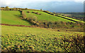
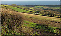
The Hollow
In the midst of a spell of sunshine that lasted a whole eight minutes, followed by weather more appropriate to the clouds in the background for the rest of the day. The Hollow is a cleft-like combe dropping from Longhouse to the Cam Brook valley at Dunkerton, and this is an upper portion, seen from Withyditch Lane.
Image: © Derek Harper
Taken: 6 Dec 2019
0.17 miles
4
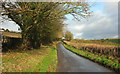
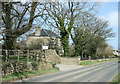
Withyditch Lane
The lane climbs from where http://www.geograph.org.uk/search.php?i=107037948 were taken, to the B3115 at Longhouse. The trees on the left can be seen in Image
Image: © Derek Harper
Taken: 6 Dec 2019
0.18 miles
5
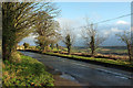
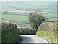
Tunley Road
The B3115 passing North Hill Farm. On the right is a view over the Cam Brook valley.
Image: © Derek Harper
Taken: 6 Dec 2019
0.19 miles
6
Houses, Longhouse
Looking left from Image], so across the top of The Hollow.
Image: © Derek Harper
Taken: 6 Dec 2019
0.19 miles
7
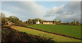
2008 : North Hill Farm
Near Tunley on the B3115.
Image: © Maurice Pullin
Taken: 1 Apr 2008
0.20 miles
8
Slopes of Cam Brook valley
Taken just across the road from Image In the centre is Manor Farm. The lien of trees on the right are along Withyditch Lane, as seen on the left of Image
Image: © Derek Harper
Taken: 6 Dec 2019
0.20 miles
9
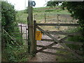
Path around Manor Farm
Some of the footpaths around Dunkerton, with an old-fashioned iron kissing gate.
Image: © Neil Owen
Taken: 9 Jun 2020
0.20 miles
10
2008 : Lane to Priston
The lane to the right goes to the much geographed Nailwell.
We can just see a corner of Priston on the other side of the valley. At the top of the picture another lane winds its way toward Marksbury.
Image: © Maurice Pullin
Taken: 1 Apr 2008
0.20 miles