IMAGES TAKEN NEAR TO
West Coker Hill, YEOVIL, BA22 9DG
Introduction
This page details the photographs taken nearby to West Coker Hill, BA22 9DG by members of the Geograph project.
The Geograph project started in 2005 with the aim of publishing, organising and preserving representative images for every square kilometre of Great Britain, Ireland and the Isle of Man.

There are currently over 7.5m images from over14,400 individuals and you can help contribute to the project by visiting https://www.geograph.org.uk
Image Map
Images are licensed for reuse under creativecommons.org/licenses/by-sa/2.0
Notes
- Clicking on the map will re-center to the selected point.
- The higher the marker number, the further away the image location is from the centre of the postcode.
Image Listing (12 Images Found)
Images are licensed for reuse under creativecommons.org/licenses/by-sa/2.0
Image
Details
Distance
2

Field, Coker Hill
Looking left from where Image was taken, again towards and across the Chinnock Brook valley.
Image: © Derek Harper
Taken: 27 Apr 2019
0.11 miles
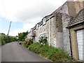
3
West Coker Hill
From where Image] and Image were taken, looking left. The South Somerset Cycle Route RR30 follows the lane here. Not far behind the camera the lane crosses Coker Hill Bridge over the A30; the turning on the left here is to properties on the main road.
Image: © Derek Harper
Taken: 27 Apr 2019
0.14 miles
4
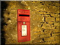
Coker Hill Postbox
Situated in Coker Hill Lane next to the bridge which crosses over the A30 (near East Chinnock) into Collarway Lane.
Image: © Sarah Smith
Taken: 13 Jan 2009
0.16 miles
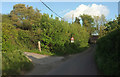
5
Near Coker Hill Bridge
This is the junction of Collarway Lane with the slip road on the left called West Coker Hill down to the A30. Straight ahead is the bridge over the main road and Coker Hill. A close-up view is Image
Image: © Sarah Smith
Taken: 26 Feb 2009
0.19 miles
6
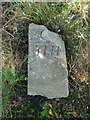
Old Boundary Stone, West Coker / East Chinnock
A curious broken stone. This was lying exactly at the position of a boundary stone (on maps up to 1962). The inscription could be interpreted signifying a "county" stone, marking the extent of responsibility for the bridge if it was C / YHD (Yeovil Hundred Division).
Inscription: C / YHI
Milestone Society National ID: SO_WCOECH01pb
Image: © Mr Red
Taken: 29 Jul 2022
0.19 miles
7
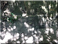
Old Milestone, West Coker / A30
On the NW side of the A30 in a cutting. Near the bridge carrying the West Coker Hill / Collarway Lane road. It is difficult to get to on foot, the verges are slight and the cutting long, under the bridge non-existent verges. This image was taken from a slow moving vehicle. At one time the inscription would have included "Crewkerne 5", currently the destination is on the plate.
Inscription: IV / Yeoville
Grade II listed see https://historicengland.org.uk/listing/the-list/list-entry/1417785
Milestone Society National ID: SO_YVCW04
Image: © Mr Red
Taken: 29 Jul 2022
0.20 miles
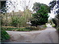
8
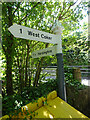
Old Fingerpost, West Coker Hill / A30
At the junction of Collarway Lane, West Coker Hill and the A30 slip road and the bridge over the A30. An image of the makers' Inscription is Image
The context view is Image
Inscription: 1 West Coker // 1 Hardington //
(on post) Somerset // Sheldon Wells
Milestone Society National ID: SO_ST5013A
Image: © Mr Red
Taken: 29 Jul 2022
0.20 miles
9
Old Fingerpost, West Coker Hill / above A30
At the junction of Collarway Lane, West Coker Hill and the A30 slip road and the bridge over the A30. The view of the fingers is Image
Image: © Mr Red
Taken: 29 Jul 2022
0.20 miles
10

Bison on Coker Hill
Diversification in deepest Somerset, the farmer here has just started keeping bison.
Image: © Rupert Fleetingly
Taken: 18 Aug 2006
0.23 miles