IMAGES TAKEN NEAR TO
Mount Road, BATH, BA2 1LQ
Introduction
This page details the photographs taken nearby to Mount Road, BA2 1LQ by members of the Geograph project.
The Geograph project started in 2005 with the aim of publishing, organising and preserving representative images for every square kilometre of Great Britain, Ireland and the Isle of Man.

There are currently over 7.5m images from over14,400 individuals and you can help contribute to the project by visiting https://www.geograph.org.uk
Image Map
Images are licensed for reuse under creativecommons.org/licenses/by-sa/2.0
Notes
- Clicking on the map will re-center to the selected point.
- The higher the marker number, the further away the image location is from the centre of the postcode.
Image Listing (31 Images Found)
Images are licensed for reuse under creativecommons.org/licenses/by-sa/2.0
Image
Details
Distance
1
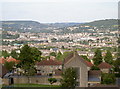
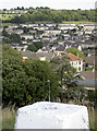
In between the hills
Looking from Southdown, past St Barnabas church in the foreground and onto the city of Bath, nestled between the many surrounding hills.
Image: © Neil Owen
Taken: 21 Jul 2008
0.04 miles
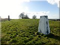
2
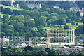
2008 : North east from Trigpoint 6624
Using the trigpoint pillar as a convenient camera support we have a clear view of the gasholders near Windsor Bridge between Upper Bristol Road and Lower Bristol Road.
Royal Victoria Park and High Common give a rural appearance.
Image: © Maurice Pullin
Taken: 14 Jul 2008
0.05 miles
3
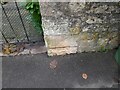
Ordnance Survey Cut Mark
This OS cut mark can be found on the gatepost of No70 Mount Road. It marks a point 114.521m above mean sea level.
Image: © Adrian Dust
Taken: 2 Dec 2022
0.06 miles
4

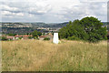
'High View'
Colour image of the park bench at the top of Roundhill (Twerton Roundhill) Bath.
With the overhead, cloud diffused morning 'light' at the top of the image.
More detailed 'dark' at the bottom of the image, distant horizon in the middle.
A simple image, seen while passing by on the 'level' after climbing the slope.
Image: © D M Wilmot
Taken: 16 Jan 2022
0.07 miles
5

Ordnance Survey Cut Mark
This OS cut mark can be found on No20 The Circle. It marks a point 112.949m above mean sea level.
Image: © Adrian Dust
Taken: 2 Dec 2022
0.08 miles
6
Twerton Roundhill in Bath
Trig point still in evidence.
Image: © Rick Crowley
Taken: 17 Jul 2010
0.09 miles
7

2008 : Flush Bracket on the trigpoint on High Barrow Hill, Southdown
My Geographia plan of the City of Bath names this site "High Barrow Hill" while OS Explorer 155 has the name "Southdown" printed over it.
The reference number TP6624, was allocated by the T:UK website http://www.trigpointinguk.com/ because they did not have access to the official numbers at the time. The number on the identification plate attached to the pillar, which is the official number(!) is S3230.
Information supplied by Barry Hunter.
Image: © Maurice Pullin
Taken: 14 Jul 2008
0.09 miles
8

Trig Point 6624 Twerton Hill
A multicoloured trig point, fine views to the south
Image: © Damon Knight
Taken: 13 Jan 2007
0.09 miles
9
Southdown
Parked on pavement of main road then a short walk uphill to bag the trig and nearby summit.
Name: Southdown
Hill number: 18215
Height: 141m / 463ft
Parent (Ma/M): 2891 Beacon Batch
Section: 41: South Central England
County/UA: Bath and NE Somerset (CoU)
Class: Unclassified
Grid ref: ST724633 (est)
Drop: 27m
Col: 114m ST726630
Image: © Rude Health
Taken: 26 Mar 2015
0.10 miles
10
From the top of Southdown
Looking from the trig pillar across the suburbs of Bath.
Image: © Neil Owen
Taken: 21 Jul 2008
0.10 miles