
IMAGES TAKEN NEAR TO
Primrose Lane, YEOVIL, BA21 5SH
Introduction
This page details the photographs taken nearby to Primrose Lane, BA21 5SH by members of the Geograph project.
The Geograph project started in 2005 with the aim of publishing, organising and preserving representative images for every square kilometre of Great Britain, Ireland and the Isle of Man.

There are currently over 7.5m images from over14,400 individuals and you can help contribute to the project by visiting https://www.geograph.org.uk
Image Map
Images are licensed for reuse under creativecommons.org/licenses/by-sa/2.0
Notes
- Clicking on the map will re-center to the selected point.
- The higher the marker number, the further away the image location is from the centre of the postcode.
Image Listing (6 Images Found)
Images are licensed for reuse under creativecommons.org/licenses/by-sa/2.0
Image
Details
Distance
1
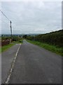
Primrose Lane, Yeovil
This is the Yeovil end of Primrose Lane that leads towards Up Mudford. I know that the road signs indicate that you could legally travel at up to 60 m.p.h. down this road but having met a tractor coming the other way a little way down I must say it is not a good idea to do so - lucky I wasn't!
Image: © Steve Barnes
Taken: 17 Aug 2009
0.11 miles
2
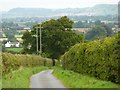
Primrose Lane towards Up Mudford.
Views, Trees, Power Lines but given how narrow the road is keep an eye on the road as it is popular with dog walkers, walkers and tractors.
Image: © Steve Barnes
Taken: 17 Aug 2009
0.17 miles
3
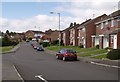
Runnymede Road, Yeovil
A road through an estate in the north-eastern part of Yeovil's suburbs. At the end can be seen a small parade of shops; the red lorry is delivering to a supermarket.
Image: © Derek Harper
Taken: 30 Aug 2007
0.20 miles
4
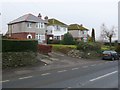
Houses on the Mudford Rd
There are only a few scattered houses along the Mudford Rd between Yeovil and Mudford. This is a small group just north of the Junction with Lyde Rd in the south of the square. The view is north west from the east side of Mudford Rd
Image: © Nigel Mykura
Taken: 27 Jan 2010
0.23 miles
5

Direction Sign - Signpost on the A359 in Mudford parish
Pyramid finial - 3 arms; Somerset SCC pyramid by the A359, in parish of Mudford (South Somerset District), on the west side of the T junction of the A359 Mudford Hill and Lyde Road.
surveyed
Milestone Society National ID: SO_ST5618
Image: © Milestone Society
Taken: Unknown
0.24 miles
6
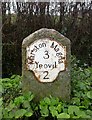
Old Milestone, A359, Mudford Hill, North of Yeovil
The milestone is located south of Oaklands on the grass verge on the west side of the road. Parish of Mudford (South Somerset District). Metal plate attached to stone post, Yeovil lobe iron plate design, erected by the Yeovil turnpike trust in the 19th century.
Inscription reads:-
Marston Magna
3
Yeovil
2
Grade II listed. List Entry Number: 1174720
https://historicengland.org.uk/listing/the-list/list-entry/1174720
Milestone Society National ID: SO_MMYV03
Image: © Mike Faherty
Taken: 16 Jan 2008
0.25 miles