IMAGES TAKEN NEAR TO
Hundred Stone Close, YEOVIL, BA21 4PD
Introduction
This page details the photographs taken nearby to Hundred Stone Close, BA21 4PD by members of the Geograph project.
The Geograph project started in 2005 with the aim of publishing, organising and preserving representative images for every square kilometre of Great Britain, Ireland and the Isle of Man.

There are currently over 7.5m images from over14,400 individuals and you can help contribute to the project by visiting https://www.geograph.org.uk
Image Map (Loading...)


Getting Data...Please wait
Leaflet Map data © OpenStreetMap
Images are licensed for reuse under creativecommons.org/licenses/by-sa/2.0
Notes
- Clicking on the map will re-center to the selected point.
- The higher the marker number, the further away the image location is from the centre of the postcode.
Image Listing (15 Images Found)
Images are licensed for reuse under creativecommons.org/licenses/by-sa/2.0
Image
Details
Distance
1

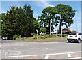
Hundredstone Garage, Yeovil
There is an Ordnance Survey benchmark on this property. See Image
Image: © Becky Williamson
Taken: 26 Jul 2015
0.03 miles
2
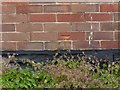
Benchmark on Hundredstone Garage, Yeovil
Ordnance Survey benchmark, described on database at http://www.bench-marks.org.uk/bm69196. See also Image
Image: © Becky Williamson
Taken: 26 Jul 2015
0.05 miles
3
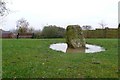
Yeovil Hundred Stone
The Yeovil Hundred Stone according to difference references is either the meeting place of the men from the hundred ( a Saxon administrative area that contributed 100 men to the standing army), or it is the boundary stone where several hundreds meet.
The lane along side is Stone Lane and the farm just to the north is Stone Farm
Image: © Nigel Mykura
Taken: 31 Jan 2009
0.05 miles
4
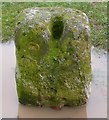
Yeovil Hundred Stone (detail)
At the junction of Stone Lane and Mudford Rd this stone could be a boundary stone or a meeting stone. The stone is grooved with a notch that may have been a hole at one time. One reference states it has a roman carving on it but none was evident.
Image: © Nigel Mykura
Taken: 31 Jan 2009
0.06 miles
5
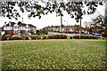
Yeovil: Mudford Road as seen from Hundred Stone
Image: © Mr Eugene Birchall
Taken: 24 Jan 2011
0.06 miles
6

Yeovil: Place of The Hundred Stone
Historical meeting place of Head Men who gathered to deal with legislative matters brought before them.
Image: © Mr Eugene Birchall
Taken: 24 Jan 2011
0.06 miles
7
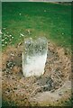
Old Boundary Marker off Mudford Road
Commemorative Marker in a small public garden on the northeast corner of the crossroads of the A359 Mudford Road, Stone Lane and Combe Street Lane. Mudford parish. The parish boundary between Mudford and Yeovil Without passes to the west and south of the stone. This marks the gathering place of the moot of Stone Hundred, the headmen of places providing one hundred men for the monarch's service. Grade II Listed details https://historicengland.org.uk/listing/the-list/list-entry/1056801. See also https://www.geograph.org.uk/photo/1145505 and https://www.geograph.org.uk/photo/1145506.
Milestone Society National ID: SO_MUDF01cm
Image: © S Melligan
Taken: Unknown
0.06 miles
8
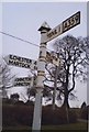
Direction Sign - Signpost by the A359 Mudford Road
Pyramid finial - 4 arms; Somerset pointing fingers by the A359, in parish of Yeovil Without (South Somerset District), on the northeast side of the crossroads of the A359 Mudford Road, Stone Lane and Combe Street Lane.
Surveyed
Milestone Society National ID: SO_ST5517
Image: © Milestone Society
Taken: Unknown
0.06 miles