IMAGES TAKEN NEAR TO
Bloomfield Avenue, BATH, BA2 0LW
Introduction
This page details the photographs taken nearby to Bloomfield Avenue, BA2 0LW by members of the Geograph project.
The Geograph project started in 2005 with the aim of publishing, organising and preserving representative images for every square kilometre of Great Britain, Ireland and the Isle of Man.

There are currently over 7.5m images from over14,400 individuals and you can help contribute to the project by visiting https://www.geograph.org.uk
Image Map
Images are licensed for reuse under creativecommons.org/licenses/by-sa/2.0
Notes
- Clicking on the map will re-center to the selected point.
- The higher the marker number, the further away the image location is from the centre of the postcode.
Image Listing (19 Images Found)
Images are licensed for reuse under creativecommons.org/licenses/by-sa/2.0
Image
Details
Distance
1
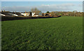
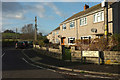
Field and houses, Timsbury
The field is crossed by footpath CL 21/8. The house in the centre is at the junction of Lippiatt Lane with Bloomfield Park Road.
Image: © Derek Harper
Taken: 9 Dec 2019
0.10 miles
2
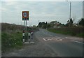
Looking toward Bloomfield
Plenty of warning as to the speed limit in the Bloomfield area of Somerset
Image: © Donnylad
Taken: 9 Apr 2007
0.11 miles
3
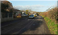
Lippiatt Lane
With houses on one side and a road side hedge on the other hiding the field shown in Image
Image: © Derek Harper
Taken: 9 Dec 2019
0.14 miles
4
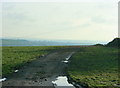
2009 : West of south from Bloomfield Road
Looking toward Paulton and Midsomer Norton.
The small hillock in the distance right of centre is a slag heap or batch from a disused coal mine.
Image: © Maurice Pullin
Taken: 13 Feb 2009
0.15 miles
5
Cul-de-sac, Lippiatt Lane
The addresses of houses in this close is still Lippiatt Lane. The hill in the background is The Sleight.
Image: © Derek Harper
Taken: 9 Dec 2019
0.15 miles
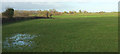
7
Field north of Timsbury
Looking right from beyond the gate shown in Image The houses on the left are on Upper Furlong.
Image: © Derek Harper
Taken: 9 Dec 2019
0.16 miles
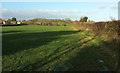
8
Grass field, Timsbury
Looking the other way from Image
Image: © Derek Harper
Taken: 9 Dec 2019
0.17 miles
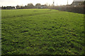
9

Kissing gate, Crocombe
Footpath CL 21/8 and /9 meets at the camera position; beyond the gate it's CL 21/8 that has precedence. The houses are also shown in Image
Image: © Derek Harper
Taken: 9 Dec 2019
0.17 miles
10
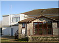
Timsbury Cricket Club
Attached to the Conygre Hall and suitably white. Timsbury are in the Bristol & District Cricket Association Senior Division for 2015 and run three teams.
One historical item worth mentioning was the club's innovative method of drying a wet wicket in 1983: former Somerset C.C.C. captain, Brian Rose, was due to appear in a testimonial match but the weather leading up to it was foul. Club chairman Eric Nott half-heartedly claimed they ought to get a helicopter to dry it out. Somehow the idea was taken seriously and thanks to sponsor involvement a helicopter arrived to hover above the batting strip!
Image: © Neil Owen
Taken: 9 Feb 2015
0.19 miles