IMAGES TAKEN NEAR TO
Poor Hill, BATH, BA2 0FP
Introduction
This page details the photographs taken nearby to Poor Hill, BA2 0FP by members of the Geograph project.
The Geograph project started in 2005 with the aim of publishing, organising and preserving representative images for every square kilometre of Great Britain, Ireland and the Isle of Man.

There are currently over 7.5m images from over14,400 individuals and you can help contribute to the project by visiting https://www.geograph.org.uk
Image Map
Images are licensed for reuse under creativecommons.org/licenses/by-sa/2.0
Notes
- Clicking on the map will re-center to the selected point.
- The higher the marker number, the further away the image location is from the centre of the postcode.
Image Listing (84 Images Found)
Images are licensed for reuse under creativecommons.org/licenses/by-sa/2.0
Image
Details
Distance
1
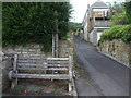
A rest halfway up Poor Hill
This seat is in a good spot overlooking most of the village and is dedicated to a local W.I. woman.
Image: © Neil Owen
Taken: 17 Jun 2020
0.02 miles
2
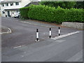
A poor spot for parking
This odd shaped junction on Poor Hill is a private road and it seems the residents have some control over the use by motor vehicles, but not total.
Image: © Neil Owen
Taken: 17 Jun 2020
0.02 miles
3

The top of Poor Hill is blocked
A steep road into Farmborough at the junction with the main Bath Road is now barred off to traffic. Perhaps not surprisingly with the amount of cars and lorries using the A39.
Image: © Neil Owen
Taken: 17 Jun 2020
0.02 miles
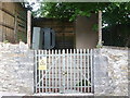
4
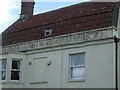
The old Bell Inn has a few words
Some painted text over the former Bell Inn in Farmborough. See https://www.geograph.org.uk/photo/6511217 for a wider view.
Image: © Neil Owen
Taken: 17 Jun 2020
0.03 miles
5
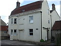
The old Bell Inn
The Bell Inn was one of about five pubs in the village of Farmborough. There is a record of a land auction being held there in 1798, but the inn is now a private residence after closing in the post-WWII era. See https://www.geograph.org.uk/photo/6511222 for a better look at some painted text below the roofline.
Image: © Neil Owen
Taken: 17 Jun 2020
0.03 miles
6
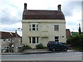
House on the Bath Rd
At the top of Poor Hill which is the steep walk way going down to the left of the building, this house with a mansard roof appears as if it may have been a pub at one time.
Image: © Nigel Mykura
Taken: 18 Sep 2011
0.03 miles
7
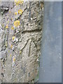
Benchmark at the top of Poor Hill
A cutmark, as listed in the Benchmark Database: https://www.bench-marks.org.uk/bm126101 , behind a modern signpost at the top of Poor Hill in Farmborough. The mark is a replacement for an earlier benchmark that used to be on the Bell Inn, just across the junction. Presumably the latter was lost or rendered unusable so this one was created. See Image] for a wider view.
Image: © Neil Owen
Taken: 17 Jun 2020
0.03 miles
8
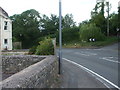
The junction of Poor Hill and the Bath Road
Here the main road (the A39) runs along the north of Farmborough. As it passes the top of Poor Hill, opposite Hunstrete Road, it goes past a benchmark on the wall close to the lamppost. See Image] for a look.
Image: © Neil Owen
Taken: 17 Jun 2020
0.03 miles
9
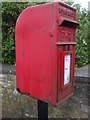
The letters might fall out
A post box on the Bath Road in Farmborough is losing the battle against corrosion. Not only might the post drop through eventually but snails might find their way in too. Not good news.
Image: © Neil Owen
Taken: 17 Jun 2020
0.03 miles
10
Power on Poor Hill
A substation near the bottom of the hill.
Image: © Neil Owen
Taken: 17 Jun 2020
0.04 miles