
IMAGES TAKEN NEAR TO
Bathford Hill, BATH, BA1 7SY
Introduction
This page details the photographs taken nearby to Bathford Hill, BA1 7SY by members of the Geograph project.
The Geograph project started in 2005 with the aim of publishing, organising and preserving representative images for every square kilometre of Great Britain, Ireland and the Isle of Man.

There are currently over 7.5m images from over14,400 individuals and you can help contribute to the project by visiting https://www.geograph.org.uk
Image Map
Images are licensed for reuse under creativecommons.org/licenses/by-sa/2.0
Notes
- Clicking on the map will re-center to the selected point.
- The higher the marker number, the further away the image location is from the centre of the postcode.
Image Listing (27 Images Found)
Images are licensed for reuse under creativecommons.org/licenses/by-sa/2.0
Image
Details
Distance
1
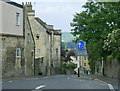
2008 : High Street, Bathford
High Street is an unrelieved climb through Bathford with no chance of refreshments and only the annoying traffic calming measures to provide amusement.
Image: © Maurice Pullin
Taken: 20 May 2008
0.01 miles
2

Church Street
Road junction in Bathford.
Image: © Wayland Smith
Taken: 30 Aug 2020
0.03 miles
3

Church Street
View across Bathford Hill into Church Street. The clean house on the right was the location of the Lower Shop and Post Office until it was moved to its new home where The Inn used to be.
Image: © Derek Hawkins
Taken: 2 Mar 2002
0.05 miles
4

The Post Office at Bathford
The Post Office at Bathford is in a prominent position as you travel up the hill towards Kingsdown.
Image: © Phil Williams
Taken: 13 Oct 2005
0.06 miles
5

Dovers Lane
Just off Bathford Hill with its shop and houses is this very rural lane.
Image: © HelenK
Taken: 30 Jul 2015
0.08 miles
6
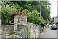
2008 : Bathford Bakery Est 1777
The sign stands outside a cottage probably dating from that time but the bakery was gone.
In the other half of the frame we are looking up High Street, the road reaches Kingsdown in a little over a mile and is uphill all the way.
Image: © Maurice Pullin
Taken: 20 May 2008
0.08 miles
7

Church Street
View along Church Street towards Bathford Hill.
Image: © Derek Hawkins
Taken: 2 Mar 2002
0.09 miles
8

Bathford School
The Primary school moved from its old location on Church Street to this location from 1965 to 1970, with the old school building sold off in 1972.
Image: © Derek Hawkins
Taken: 2 Mar 2002
0.12 miles
9
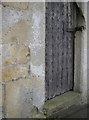
Lock-up benchmark
This cutmark appears on the old lock-up, where many an intoxicated reveller would have been kept until sober. See Image] for a wider view and http://www.bench-marks.org.uk/bm72040 for the entry in the Benchmark Database.
Image: © Neil Owen
Taken: 8 Dec 2015
0.13 miles
10
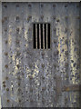
Just a grille to peer out of
Anyone finding themselves in this old lock-up would not have a chance of escaping through this opening. Bathford had a two-cell lock-up - perhaps it had something to do with being close to the Crown inn just down the hill.
See Image] for a wider view of the old drunk tank.
Image: © Neil Owen
Taken: 8 Dec 2015
0.13 miles