IMAGES TAKEN NEAR TO
Westbury Road, WESTBURY, BA13 4PG
Introduction
This page details the photographs taken nearby to Westbury Road, BA13 4PG by members of the Geograph project.
The Geograph project started in 2005 with the aim of publishing, organising and preserving representative images for every square kilometre of Great Britain, Ireland and the Isle of Man.

There are currently over 7.5m images from over14,400 individuals and you can help contribute to the project by visiting https://www.geograph.org.uk
Image Map
Images are licensed for reuse under creativecommons.org/licenses/by-sa/2.0
Notes
- Clicking on the map will re-center to the selected point.
- The higher the marker number, the further away the image location is from the centre of the postcode.
Image Listing (48 Images Found)
Images are licensed for reuse under creativecommons.org/licenses/by-sa/2.0
Image
Details
Distance
1
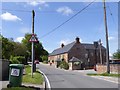
The Three Daggers inn, Edington
Formerly the Lamb Inn Image and much changed in appearance since 2006
Image: © David Smith
Taken: 1 Jun 2017
0.01 miles
2
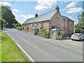
Edington, Three Daggers
Good Beer Guide-listed village pub on Westbury Road. Back counter, drinking areas front, left and right; dining at back. Wooden beams, garden, playground. Cask ales on offer at my visit (brewed next door at Image): Daggers Ale, Black, Blonde, Edge.
Image: © Mike Faherty
Taken: 25 Jul 2017
0.02 miles
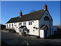
3
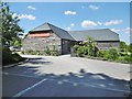
![Edington buildings [1]](https://s2.geograph.org.uk/geophotos/06/49/58/6495842_6cb3b6d3_120x120.jpg)
Edington buildings [1]
Occupying the site of a 1750 building the Three Daggers Inn is Victorian. Previously known as The Lamb, the inn is a micro brewery and home to a farm shop.
Edington is a former agricultural village which lies on the ‘springline’ of the northern escarpment of Salisbury Plain about 4 miles east of the town of Westbury. A priory was founded in the 14th century and became a monastery of the Brothers of Penitence, or Bonshommes. The magnificent monastery church continues in use as the parish church and is the home of the nationally-known annual Edington Music Festival.
Image: © Michael Dibb
Taken: 24 Apr 2020
0.02 miles
4
Edington: the post office
An unassuming little post office which is open 9 till 12 each weekday.
Image: © Chris Downer
Taken: 16 Aug 2007
0.03 miles
6
![Edington buildings [2]](https://s3.geograph.org.uk/geophotos/06/49/58/6495855_147fc33b_120x120.jpg)
Edington buildings [2]
Now two private houses, Edington school was built in 1870 and closed in 1996 due to falling numbers.
Edington is a former agricultural village which lies on the ‘springline’ of the northern escarpment of Salisbury Plain about 4 miles east of the town of Westbury. A priory was founded in the 14th century and became a monastery of the Brothers of Penitence, or Bonshommes. The magnificent monastery church continues in use as the parish church and is the home of the nationally-known annual Edington Music Festival.
Image: © Michael Dibb
Taken: 24 Apr 2020
0.04 miles
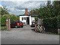
7
Edington Farm Shop
On Westbury Road; home to Three Daggers Brewery, served next door at Image https://www.threedaggers.co.uk/brewery https://www.threedaggers.co.uk/farm-shop
Image: © Mike Faherty
Taken: 25 Jul 2017
0.04 miles
8
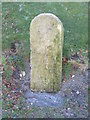
Milestone at Tinhead Edington
Recently rescued from a vulnerable position along the Erlestoke Road, where it was being damaged by flails. Sign reputed to have once been labelled "London 97". No visible writing remains. The sign is now at the foot of the Old Coaching Road where it crosses the modern road along the spring line beneath Salisbury Plain.
Image: © Peter Watkins
Taken: 29 Jan 2006
0.05 miles
9
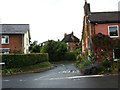
Edington: junction of Tinhead Road with the B3098
Image: © David Gearing
Taken: 25 Aug 2012
0.05 miles
10
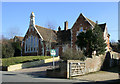
2010 : Old school house, Edington
Seen from the B3098 Westbury Road. Now converted to a private house and for sale.
Image: © Maurice Pullin
Taken: 5 Mar 2010
0.06 miles