IMAGES TAKEN NEAR TO
Tanyard Way, WESTBURY, BA13 3GW
Introduction
This page details the photographs taken nearby to Tanyard Way, BA13 3GW by members of the Geograph project.
The Geograph project started in 2005 with the aim of publishing, organising and preserving representative images for every square kilometre of Great Britain, Ireland and the Isle of Man.

There are currently over 7.5m images from over14,400 individuals and you can help contribute to the project by visiting https://www.geograph.org.uk
Image Map
Images are licensed for reuse under creativecommons.org/licenses/by-sa/2.0
Notes
- Clicking on the map will re-center to the selected point.
- The higher the marker number, the further away the image location is from the centre of the postcode.
Image Listing (72 Images Found)
Images are licensed for reuse under creativecommons.org/licenses/by-sa/2.0
Image
Details
Distance
1
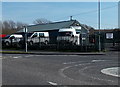
Quality Vans Online Ltd in Dilton Marsh
Van and truck sales business at 1 Tanyard Way.
Image: © Jaggery
Taken: 8 Mar 2014
0.01 miles
2

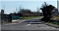
Infrastructure east of Dilton Marsh railway station
The mini roundabout in the foreground is in this square as is the area of black tarmac in the right foreground, the site of which would seem to have been cleared since the last Google Earth flyover. The tall chimney on the skyline is that of the Lafarge cement works in ST8852/8952.
Image: © Brian Robert Marshall
Taken: 12 Dec 2007
0.03 miles
3
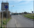
Towards the southern end of High Street, Dilton Marsh
South of the mini-roundabout at the Tanyard Way junction, High Street loses its B-road (B3099) status and resembles a country lane. Out of shot ahead, High Street passes the eastern end of Petticoat Lane and ends at the edge of the A3098. Metal posts across High Street at that point mean that it is not a through route for cars or lorries.
Image: © Jaggery
Taken: 8 Mar 2014
0.04 miles
5
Round and round in circles in Dilton Marsh
This All routes sign at the edge of High Street is intended to show how to negotiate the mini-roundabout ahead but it does invite humorous comments, such as Wiltshire's least informative destination sign...
Image: © Jaggery
Taken: 8 Mar 2014
0.04 miles
6
![Dilton Marsh ways [1]](https://s0.geograph.org.uk/geophotos/06/80/90/6809096_66ecd7e1_120x120.jpg)
Dilton Marsh ways [1]
High Street, seen here as it comes to its end near the Penknap Baptist church Image is anything but high.
Dilton Marsh is a linear village with a high street over one mile long. The village is about 1½ miles south west of the centre of the town of Westbury. The original settlement, Old Dilton, is some ¾ miles south east of the present village centre on the banks of the Biss Brook and is now no more than a couple of farm houses and the ancient St Mary's Church.
Image: © Michael Dibb
Taken: 9 Feb 2021
0.06 miles
7
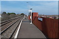
Platform 2 at Dilton Marsh railway station
This platform is for arrivals from the north (Westbury) and departures south to Warminster and Salisbury. The platform is so short that only the front door of the leading carriage is opened. On the train I was on , a couple of minutes after leaving Westbury, the ticket inspector walked through the train towards the front saying "Anyone for Dilton Marsh follow me". I was one of two passengers to alight.
Platform 1, for Westbury, is about 100 metres ahead
Image: © Jaggery
Taken: 8 Mar 2014
0.07 miles
8
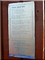
Betjeman poem, Dilton Marsh station
The late poet laureate John Betjeman once wrote a poem about this simple country railway station. Once under threat of closure, the station was restored in the early 1990s and, in 1994 his daughter, Candida Lycett Green unveiled this plaque on the 'down' platform, which contains the text of the poem. Whilst the text is just about readable in this image, it's easier here http://www.dilton-marsh.org.uk/villages/marsh.php
Image: © Brian Robert Marshall
Taken: 12 Dec 2007
0.07 miles
9

'Down' platform, Dilton Marsh railway station
Once under threat of closure, the station was refurbished in the 1990s. This simple station shares a poetic connection with St Pancras station: John Betjeman, late poet laureate, wrote a poem about this station (the plaque bearing its word is visible on the shelter) Image and there is a statue of him at St Pancras. Both the plaque and the statue were unveiled by his daughter Candida Lycett Green.
Image: © Brian Robert Marshall
Taken: 12 Dec 2007
0.07 miles
10
![Dilton Marsh features [1]](https://s0.geograph.org.uk/geophotos/06/80/90/6809092_7107ec48_120x120.jpg)
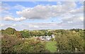
Dilton Marsh features [1]
Seen across the fields from High Street is Dilton Marsh Station, a request stop on the Bristol to Southampton line. Opened in 1937, tickets were sold from 'the seventh house up the hill'. Threatened with closure, the station was saved with the help of a poem by John Betjeman. The Wikipedia article has details at: https://en.wikipedia.org/wiki/Dilton_Marsh_railway_station
Dilton Marsh is a linear village with a high street over one mile long. The village is about 1½ miles south west of the centre of the town of Westbury. The original settlement, Old Dilton, is some ¾ miles south east of the present village centre on the banks of the Biss Brook and is now no more than a couple of farm houses and the ancient St Mary's Church.
Image: © Michael Dibb
Taken: 9 Feb 2021
0.07 miles