IMAGES TAKEN NEAR TO
Dales Road, WESTBURY, BA13 3GE
Introduction
This page details the photographs taken nearby to Dales Road, BA13 3GE by members of the Geograph project.
The Geograph project started in 2005 with the aim of publishing, organising and preserving representative images for every square kilometre of Great Britain, Ireland and the Isle of Man.

There are currently over 7.5m images from over14,400 individuals and you can help contribute to the project by visiting https://www.geograph.org.uk
Image Map
Images are licensed for reuse under creativecommons.org/licenses/by-sa/2.0
Notes
- Clicking on the map will re-center to the selected point.
- The higher the marker number, the further away the image location is from the centre of the postcode.
Image Listing (30 Images Found)
Images are licensed for reuse under creativecommons.org/licenses/by-sa/2.0
Image
Details
Distance
1

Willoughby Close, Westbury
Viewed across Leigh Park Way.
Image: © Jaggery
Taken: 8 Mar 2014
0.07 miles
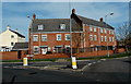
2
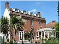
Smallbridge House
One of the oldest houses in Eden Vale Road dating back to around 1800.
Image: © Derek Jones
Taken: 18 Jun 2006
0.08 miles
3
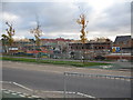
Leigh Park
Looking to the southeast, about 180 degrees from the photo of the shops at Leigh Park Local Centre in Leigh Park, Westbury, this shows some of the on-going construction work on the Leigh Park estate.
Image: © Phil Williams
Taken: 13 Nov 2005
0.08 miles
4
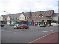
Local Centre, Leigh Park, Westbury
This is the parade of shops at Leigh Park Local Centre, part of the Leigh Park development, a new neighbourhood next to Westbury Leigh in Westbury.
The road is called Palamino Place.
Leigh Park Community Centre, Leigh Park Doctors' Surgery and Leigh Park Community Nursery are expected to be built on adjacent land to the right of the shop shortly. Together with the shops, these buildings form Leigh Park Local Centre.
Image: © Phil Williams
Taken: 13 Nov 2005
0.08 miles
5
![Westbury houses [28]](https://s0.geograph.org.uk/geophotos/06/82/47/6824736_9c613004_120x120.jpg)
Westbury houses [28]
Numbers 98 and 100 Leigh Road occupy an 'L' plan building built in the early 19th century. Constructed of brick with a pantiled roof. A 17th or early 18th century mullion and transom cross window has been inserted into the left return of number 98. Number 100 is a rear extension. Listed, grade II, with details at: https://historicengland.org.uk/listing/the-list/list-entry/1036297
Westbury is a former market town in the far west of Wiltshire under the north western edge of Salisbury Plain, 4 miles south of Trowbridge and 4 miles north of Warminster. Westbury was a centre of the cloth industry from the later 15th century until the 19th century. Malting was another important industry. There are now a number of large industrial and trading estates around the town with many residents working there. The town is an important junction point on the railway network with the Reading to Taunton line intersecting the line from Bristol to Southampton.
Image: © Michael Dibb
Taken: 29 Apr 2021
0.10 miles
6
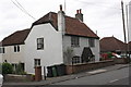
#98 Leigh Road
There is an OS benchmark Image on the front of the house below the white chimney
Image: © Roger Templeman
Taken: 17 Sep 2012
0.10 miles
7
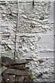
Benchmark on #98 Leigh Road
Ordnance Survey cut mark benchmark described on the Bench Mark Database at http://www.bench-marks.org.uk/bm45430
Image: © Roger Templeman
Taken: 17 Sep 2012
0.10 miles
8
Mustang Close, Westbury
Housing at the southern edge of Mustang Close, viewed across Leigh Park Way.
Image: © Jaggery
Taken: 8 Mar 2014
0.10 miles
9
![Westbury houses [27]](https://s1.geograph.org.uk/geophotos/06/82/47/6824733_b9666f9e_120x120.jpg)
Westbury houses [27]
Number 90 Leigh Road is mid or late 18th century. Built in red brick with dark headers under an old tile roof. A later extension at the rear has a pantiled roof. Listed, grade II, with details at: https://historicengland.org.uk/listing/the-list/list-entry/1364394
Westbury is a former market town in the far west of Wiltshire under the north western edge of Salisbury Plain, 4 miles south of Trowbridge and 4 miles north of Warminster. Westbury was a centre of the cloth industry from the later 15th century until the 19th century. Malting was another important industry. There are now a number of large industrial and trading estates around the town with many residents working there. The town is an important junction point on the railway network with the Reading to Taunton line intersecting the line from Bristol to Southampton.
Image: © Michael Dibb
Taken: 29 Apr 2021
0.11 miles
10
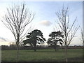
Trees, old and new
A view looking to the northwest across an open area at Leigh Park, showing two old yew trees framed by new saplings planted as part of the housing development.
Image: © Phil Williams
Taken: 17 Jan 2006
0.12 miles