IMAGES TAKEN NEAR TO
Norton Bavant, WARMINSTER, BA12 7BA
Introduction
This page details the photographs taken nearby to BA12 7BA by members of the Geograph project.
The Geograph project started in 2005 with the aim of publishing, organising and preserving representative images for every square kilometre of Great Britain, Ireland and the Isle of Man.

There are currently over 7.5m images from over14,400 individuals and you can help contribute to the project by visiting https://www.geograph.org.uk
Image Map
Images are licensed for reuse under creativecommons.org/licenses/by-sa/2.0
Notes
- Clicking on the map will re-center to the selected point.
- The higher the marker number, the further away the image location is from the centre of the postcode.
Image Listing (14 Images Found)
Images are licensed for reuse under creativecommons.org/licenses/by-sa/2.0
Image
Details
Distance
1
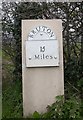
Old Milestone south of Norton Bavant, Heytesbury parish
Metal plate attached to concrete post by the UC road, in parish of HEYTESBURY (WEST WILTSHIRE District), 100m East of junction with road to Norton Bavant, 50m East of Langleys Gore, in hedgerow, on North side of road. Bruton Sun iron plate, erected by the Bruton turnpike trust in the 18th century.
Inscription reads:-
BRUTON
15
Miles
Milestone Society National ID: WI_BNMB15.
Image: © M Faherty
Taken: 1 Apr 2007
0.03 miles
2
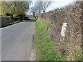
Minor road near Norton Bavant
Beside the minor road is a late 18th century milestone. For a closer view of the milestone Image
Image: © Maigheach-gheal
Taken: 14 Mar 2011
0.03 miles
3
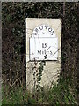
Milestone near Norton Bavant
The limestone pillar with its cast iron plate dates from the late 18th century and indicates it is 15 miles to Bruton. The Bruton to Norton Bavant road was turnpiked 1792-3.
Image: © Maigheach-gheal
Taken: 14 Mar 2011
0.04 miles
4
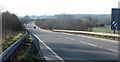
2011 : A36 Warminster bypass, eastern end looking west
The River Wylye passes along the valley to the right.
A speed camera warning keeps company with a speed derestriction sign.
Image: © Maurice Pullin
Taken: 30 Jan 2011
0.15 miles
5
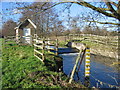
Recorder House at Norton Bavant
A view looking northwest along the River Wylye to the building housing the depth recorder for the River Wylye at Norton Bavant. See http://www.nwl.ac.uk/ih/nrfa/station_summaries/043/012.html for more information on this weir.
Image: © Phil Williams
Taken: 21 Jan 2006
0.18 miles
6
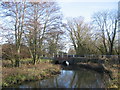
River Wylye at Norton Bavant
A view looking southeast (downstream) towards the bridge carrying the minor road from Sutton Veny to Heytesbury over the River Wylye.
Image: © Phil Williams
Taken: 21 Jan 2006
0.18 miles
7
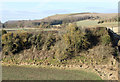
2011 : North west from the A36
At the eastern end of the Warminster bypass.
Battlesbury Hill Image is central on the horizon.
Image: © Maurice Pullin
Taken: 30 Jan 2011
0.18 miles
8
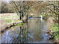
River Wylye, Norton Bavant
The Wylye is generally regarded as the most notable of the Avon tributaries.
Looking upstream.
Image: © Maigheach-gheal
Taken: 19 Mar 2011
0.20 miles
9
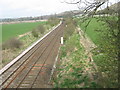
Railway near Sutton Veny going into Warminster
Image: © Dr Duncan Pepper
Taken: 6 Apr 2009
0.22 miles
10
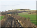
Scratchbury Hill
A view looking northwest along the rail line towards the skew bridge on the B3414, with the earthworks of the hill fort visible on Scratchbury Hill in the background.
Image: © Phil Williams
Taken: 22 Jan 2006
0.22 miles