IMAGES TAKEN NEAR TO
Norton Bavant, WARMINSTER, BA12 0EN
Introduction
This page details the photographs taken nearby to BA12 0EN by members of the Geograph project.
The Geograph project started in 2005 with the aim of publishing, organising and preserving representative images for every square kilometre of Great Britain, Ireland and the Isle of Man.

There are currently over 7.5m images from over14,400 individuals and you can help contribute to the project by visiting https://www.geograph.org.uk
Image Map
Images are licensed for reuse under creativecommons.org/licenses/by-sa/2.0
Notes
- Clicking on the map will re-center to the selected point.
- The higher the marker number, the further away the image location is from the centre of the postcode.
Image Listing (20 Images Found)
Images are licensed for reuse under creativecommons.org/licenses/by-sa/2.0
Image
Details
Distance
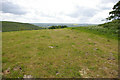
1
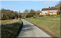
2011 : Lane to North Farm
Passing between Middle Hill, to the left, and Scratchbury Hill to the right on the way.
Image: © Maurice Pullin
Taken: 30 Jan 2011
0.03 miles
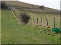
2

Byway near Middle Hill
The byway passes Middle Hill Farm to join the Imber Range Path at the foot of Middle Hill.
Image: © Maigheach-gheal
Taken: 16 Mar 2009
0.06 miles
3
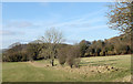
Footpath, Middleton Farm
The footpath heads towards Scratchbury Hill.
Image: © Maigheach-gheal
Taken: 16 Mar 2009
0.07 miles
4
View towards Scratchbury Hill
Looking south east from the flanks of Middle Hill
Image: © Chris Heaton
Taken: 17 May 2021
0.08 miles
5
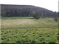
2011 : North West at the bottom of Scratchbury Hill
Among those trees the remains of the medieval village of Middleton hides. Probably a victim of the black death.
The hill in the background to the left is Battlesbury.
Image: © Maurice Pullin
Taken: 30 Jan 2011
0.08 miles
6

Byway to Middleton Farm
The way heads along the grassy track to the farm. The Imber Range Path heads to the right.
Image: © Maigheach-gheal
Taken: 16 Mar 2009
0.14 miles
7
Middle Hill
Norton Bavant is one mile away beyond Scratchbury Hill, on the left, where the worn out areas of Imber Range Path can be seen. Middle Hill Tumulus can just be seen on the right.
Image: © Roger Gittins
Taken: 20 May 2009
0.15 miles
8
Imber Range Path
The Imber Range Path heads up Scratchbury Hill.
Image: © Maigheach-gheal
Taken: 16 Mar 2009
0.16 miles
9
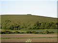
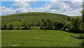
Scratchbury Hill
Seen from the B road are the distinctive features of Scratchbury Hill. Along with the ramparts of the hill fort, the barrow is clearly defined. Look closely and you can just make out the marker pole, which alerts the military from digging up the ancient site.
Image: © Neil Owen
Taken: 6 Jun 2010
0.18 miles
10
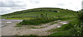
Scratchbury Hill
Imber Range Path meanders from the viewpoint to the signpost on the left then up to the hedge line then around Scratchbury Hill to the left.
For a view from the signpost see Image
Image: © Roger Gittins
Taken: 20 May 2009
0.18 miles