IMAGES TAKEN NEAR TO
Goodwin Close, WARMINSTER, BA12 0DE
Introduction
This page details the photographs taken nearby to Goodwin Close, BA12 0DE by members of the Geograph project.
The Geograph project started in 2005 with the aim of publishing, organising and preserving representative images for every square kilometre of Great Britain, Ireland and the Isle of Man.

There are currently over 7.5m images from over14,400 individuals and you can help contribute to the project by visiting https://www.geograph.org.uk
Image Map
Images are licensed for reuse under creativecommons.org/licenses/by-sa/2.0
Notes
- Clicking on the map will re-center to the selected point.
- The higher the marker number, the further away the image location is from the centre of the postcode.
Image Listing (7 Images Found)
Images are licensed for reuse under creativecommons.org/licenses/by-sa/2.0
Image
Details
Distance
1
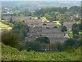
Residential development, Warminster
The properties are used by military personnel and their families. The small estate extends into two squares, this one and ST8845.
Image: © Brian Robert Marshall
Taken: 13 Sep 2008
0.01 miles
2
Battlesbury Hill, Wiltshire
Looking east towards Battlesbury Hill from the vicintiy of the MoD Warminster Training Centre. Battlesbury Camp is located on the top 0f the hill and is an Iron Age bivallate hill fort.
Image: © Rebecca A Wills
Taken: 18 Jul 2020
0.15 miles
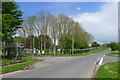
3
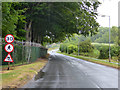
Roads signs on Imber Road
These are probably of military origin. The ban on pedestrians sign does not appear to be correct, at there is a footway on the right side of the road. It probably is intended to only ban people walking on the left side of the road.
Image: © Robin Webster
Taken: 21 Aug 2016
0.16 miles
4
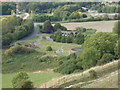
Sewage works, Warminster Military Training Centre
View from the earthwork round Battlesbury Hill.
Image: © David Hawgood
Taken: 10 Sep 2006
0.20 miles
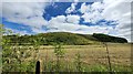
5
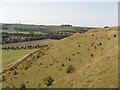
Battlesbury iron age hillfort, Salisbury Plain
This is the steep natural western slope of Battlesbury Hill, with iron age earth walls and ditches at the top. View from the fort walls on the south-west side. Photo taken during a Heritage Open Days walk with a Ministry of Defence archaeologist - but there is always public access by paths to this hill on the edge of the military training area.
Image: © David Hawgood
Taken: 10 Sep 2006
0.23 miles
6
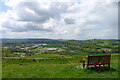
Seat on the south-west flank of Battlesbury Hill
Looking over Battlesbury Barracks, and Warminster beyond
Image: © Tim Heaton
Taken: 17 May 2021
0.23 miles
7
Imber Road at the perimeter of the MOD Warminster Training Centre
Miles of razor wire along a stretch of the Wessex Ridgeway path
Image: © Tim Heaton
Taken: 17 May 2021
0.24 miles