IMAGES TAKEN NEAR TO
Green Park, FROME, BA11 6PH
Introduction
This page details the photographs taken nearby to Green Park, BA11 6PH by members of the Geograph project.
The Geograph project started in 2005 with the aim of publishing, organising and preserving representative images for every square kilometre of Great Britain, Ireland and the Isle of Man.

There are currently over 7.5m images from over14,400 individuals and you can help contribute to the project by visiting https://www.geograph.org.uk
Image Map (61 Images)


Getting Data...Please wait
Leaflet Map data © OpenStreetMap
Images are licensed for reuse under creativecommons.org/licenses/by-sa/2.0
Notes
- Clicking on the map will re-center to the selected point.
- The higher the marker number, the further away the image location is from the centre of the postcode.
Image Listing (61 Images Found)
Images are licensed for reuse under creativecommons.org/licenses/by-sa/2.0
Image
Details
Distance
1
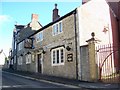
The Cross Keys, Rode
Situated on the old Fussels brewery site, the Cross Keys is steeped in history and contains many beautiful interior features.
Image: © Maigheach-gheal
Taken: 17 Nov 2009
0.03 miles
2
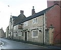
2008 : The Cross Keys, Rode
In Rode High Street the village pub was conveniently situated by the side of the old brewery before it closed. http://www.crosskeys-butcombe.com/
Image: © Maurice Pullin
Taken: 5 Jan 2008
0.04 miles
3
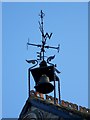
Bell on the Cross Keys Inn, Rode
This impressive bell and weather vane is on the roof of the Cross Keys Inn.
Image: © Maigheach-gheal
Taken: 17 Nov 2009
0.05 miles
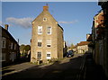
4
ChoconChoc
Deep in the heart of the little village of Rode is a successful chocolatier. The company started out in 2003 as a family concern, producing high quality hand-made chocolates. The business grew and now supplies many nationally-known shops; the firm took over this building and now produces over 63,000 tasty treats a week. The workers occupy the lower floor and can be seen through the large windows as they make the chocolates.
Image: © Neil Owen
Taken: 7 Nov 2016
0.05 miles
5
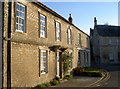
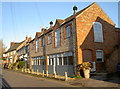
Cottages at the junction
High Street and Church Lane meet and these two cottages take prime spot.
Image: © Neil Owen
Taken: 7 Nov 2016
0.05 miles
6
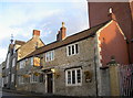
Cross Keys Inn
Rode's important watering hole was acquired by the Fussell family in the 1850s and made brewing a major employer in the village - hence the towering brick factory behind it. The inn has had a chequered past and was closed for some time but reopened in 2002.
Image: © Neil Owen
Taken: 4 Nov 2016
0.05 miles
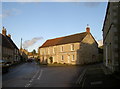
7
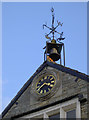
Jubilee clock
This fine timepiece, bell and weather vane sit atop the Institute Hall. The clock was installed as part of the celebrations of Queen Victoria’s golden jubilee; the United Counties Institute (founded by R. P. H. Batten Pooll) and Rev. Brickmann of Christ Church opened it, with the Jubilee Clock installed above the window.
Sadly, the clock stopped working in 1957 and remained so for some time. It was eventually restarted in 1985 following a public subscription and then overhauled in 2008.
Image: © Neil Owen
Taken: 4 Nov 2016
0.05 miles
8
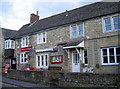
Rode Post Office
Opened in the early twentieth century and now one of very few village shops still in business.
Image: © Neil Owen
Taken: 4 Nov 2016
0.06 miles
9
Where Higher and Lower meet
The streets in Rode reach this old part where the village cross used to stand.
Image: © Neil Owen
Taken: 7 Nov 2016
0.06 miles
10
Where Lower and Higher meet
Rode's main streets converge.
Notably, the village has changed name over the years. Originally recognised as Rode, it became known as Road around 1710 following implications over a will. It remained so (and old maps show it as such) until the council decision of 1910 brought about the return of the old (and current) spelling - Rode.
Image: © Neil Owen
Taken: 4 Nov 2016
0.06 miles