IMAGES TAKEN NEAR TO
Warminster Road, FROME, BA11 5LA
Introduction
This page details the photographs taken nearby to Warminster Road, BA11 5LA by members of the Geograph project.
The Geograph project started in 2005 with the aim of publishing, organising and preserving representative images for every square kilometre of Great Britain, Ireland and the Isle of Man.

There are currently over 7.5m images from over14,400 individuals and you can help contribute to the project by visiting https://www.geograph.org.uk
Image Map (Loading...)


Getting Data...Please wait
Leaflet Map data © OpenStreetMap
Images are licensed for reuse under creativecommons.org/licenses/by-sa/2.0
Notes
- Clicking on the map will re-center to the selected point.
- The higher the marker number, the further away the image location is from the centre of the postcode.
Image Listing (94 Images Found)
Images are licensed for reuse under creativecommons.org/licenses/by-sa/2.0
Image
Details
Distance
2
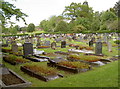
Easthill cemetery
This council-owned cemetery has a brighter future: in 2009 the decision was taken to spend £62,000 to extend the site. That should enable it to remain open for another twenty-five years.
Image: © Neil Owen
Taken: 13 May 2014
0.07 miles
3
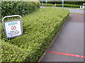
The red line spells danger!
Asda clearly don't want to loose any trolleys. However, it is not stated how this magical system of prevention will happen. Are there any magnetic mines in the pavement, a sniper in the bushes or is it down to some smoke and mirrors? See Image] for the store itself.
Image: © Neil Owen
Taken: 13 May 2014
0.08 miles
4
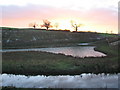
Sunset over Rodden Brook
Looking west over Rodden Brook and the frozen surface of one of the catchment ponds created as part of the flood prevention scheme associated with the ASDA store at Frome.
Image: © Phil Williams
Taken: 29 Nov 2005
0.09 miles
5
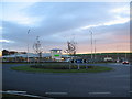
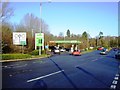
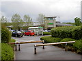
ASDA, Frome
looking southeast across the A362 at the roundabout installed to provide access to the recent (Aug 2005) ASDA store development.
Image: © Phil Williams
Taken: 29 Nov 2005
0.09 miles
6
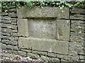
The curious case of the lowered hill
This stone in Styles Hill has weathered a bit but seems to read:
This hill was lowered
7 ??? 1861
It also has a benchmark too (an original from the nineteenth century) - see http://www.bench-marks.org.uk/bm57378 for the entry in the Benchmark Database and Image] for a wider view.
Image: © Neil Owen
Taken: 13 May 2014
0.10 miles
7
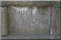
Old Boundary Marker on Styles Hill, Easthill
Commemorative Marker set in a high stone wall on the southeast side of the A3098 Styles Hill, Easthill. Frome parish. Inscribed THIS HILL / WAS LOWERED / 7 (OCT) 1861. (From Historic England) Styles Hill became a turnpike in about 1830 but since it was too steep a deeper cutting was made in 1861 and the revetment with its commemorative tablet was constructed. Grade II Listed details https://historicengland.org.uk/listing/the-list/list-entry/1345008. See also https://www.geograph.org.uk/photo/3982564.
Milestone Society National ID: SO_FROME03cm
Image: © R Raynsford
Taken: Unknown
0.10 miles
8
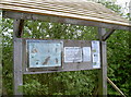
Rodden information board
A suitably rustic shelter for the local nature reserve.
Image: © Neil Owen
Taken: 13 May 2014
0.10 miles
9
Frome Asda
An out-of-town estate for the familiar supermarket. See Image] for some sinister warnings.
Image: © Neil Owen
Taken: 13 May 2014
0.11 miles
10
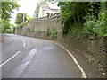
Styles Hill
The view up the A3098, from the junction with the A362 at Wallbridge - otherwise called Styles Hill. There is a stone set into the wall here, which has a curious inscription. See Image] for details.
Image: © Neil Owen
Taken: 13 May 2014
0.11 miles