IMAGES TAKEN NEAR TO
Pot Lane, BA11 5FT
Introduction
This page details the photographs taken nearby to Pot Lane, BA11 5FT by members of the Geograph project.
The Geograph project started in 2005 with the aim of publishing, organising and preserving representative images for every square kilometre of Great Britain, Ireland and the Isle of Man.

There are currently over 7.5m images from over14,400 individuals and you can help contribute to the project by visiting https://www.geograph.org.uk
Image Map
Images are licensed for reuse under creativecommons.org/licenses/by-sa/2.0
Notes
- Clicking on the map will re-center to the selected point.
- The higher the marker number, the further away the image location is from the centre of the postcode.
Image Listing (25 Images Found)
Images are licensed for reuse under creativecommons.org/licenses/by-sa/2.0
Image
Details
Distance
5
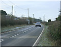
2010 : Berkley Street heading south
Seen from the end of Pot Lane.
The village is off the road to the left.
Image: © Maurice Pullin
Taken: 31 Jan 2010
0.09 miles
6
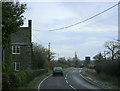
2010 : Berkley Street at the end of Pot Lane
Looking north east toward Standerwick.
Church Farm is to the left, Berkley is a short distance behind the camera.
Image: © Maurice Pullin
Taken: 31 Jan 2010
0.11 miles