IMAGES TAKEN NEAR TO
Alcester Road, BIRMINGHAM, B47 6JR
Introduction
This page details the photographs taken nearby to Alcester Road, B47 6JR by members of the Geograph project.
The Geograph project started in 2005 with the aim of publishing, organising and preserving representative images for every square kilometre of Great Britain, Ireland and the Isle of Man.

There are currently over 7.5m images from over14,400 individuals and you can help contribute to the project by visiting https://www.geograph.org.uk
Image Map
Images are licensed for reuse under creativecommons.org/licenses/by-sa/2.0
Notes
- Clicking on the map will re-center to the selected point.
- The higher the marker number, the further away the image location is from the centre of the postcode.
Image Listing (28 Images Found)
Images are licensed for reuse under creativecommons.org/licenses/by-sa/2.0
Image
Details
Distance
1
Houses, west side of Alcester Road, Wythall
The 1884 OS map shows well-spread out modest properties along here, while the east side of Alcester Road was largely undeveloped.
Image: © Robin Stott
Taken: 29 Mar 2014
0.04 miles
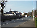
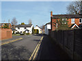
2
Houses, east side of Alcester Road, Wythall
It is not until the 1938 OS map that we see that significant residential development has taken place – along the roads but in small groups, not yet joined-up ribbon development. An old hedgerow oak is not having any suburban constraints. Postbox number B47 263.
Image: © Robin Stott
Taken: 29 Mar 2014
0.05 miles
3
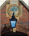
Inscription and blue lamp, Wythall Police Station, Alcester Road
The building is seen in Image The inscription is COMITATUS WIGORNIENSIS – The County of Worcestershire.
Image: © Robin Stott
Taken: 29 Mar 2014
0.08 miles
4
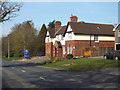
Part-time police station, Alcester Road, Wythall
An imposing building but not always manned; some information may be found here: http://wythall.info/police/
Detail at Image
Image: © Robin Stott
Taken: 29 Mar 2014
0.08 miles
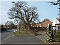
5
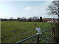
Between the built-on bits ? pasture, west side of Alcester Road, Wythall
"Rural Watch operating in this area". Behind the camera, houses; ahead, business premises of different vintages.
Image: © Robin Stott
Taken: 29 Mar 2014
0.09 miles
6
Chapel Drive, Wythall
The chapel is the white building half-hidden on the right Image It is shown on an OS map of 1884. Church Close, to the left, is a modern residential road although the beginnings of it are on the 1884 map.
Image: © Robin Stott
Taken: 29 Mar 2014
0.11 miles
7
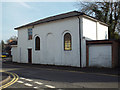
Wythall Baptist Church, Chapel Drive
The building is shown on an OS map of 1884 on the edge of a loose cluster of cottages. The setting is seen in Image
Image: © Robin Stott
Taken: 29 Mar 2014
0.12 miles
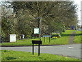
8
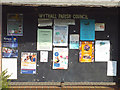
Wythall Parish Council noticeboard outside Wythall Institute, Alcester Road
A social document, of its immediate time and place.
Image: © Robin Stott
Taken: 29 Mar 2014
0.12 miles
9
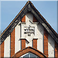
Gable tablet, Wythall Institute, Alcester Road
Image: © Robin Stott
Taken: 29 Mar 2014
0.12 miles
10
Public domain, southeast corner of Gorsey Lane and Alcester Road, Wythall
The parish council has established a presence here with a noticeboard, a litter bin, a dog waste bin and a village sign and flower box. Just south on the Alcester Road is the police station Image An old map names the area as Wythall Heath: perhaps the lanes were fringed with gorse; perhaps the pastures have been won from poor, gorse-infested land. The Gorsey Lane turning is opposite Brick Kiln Lane, another evocative name, not yet explored.
Image: © Robin Stott
Taken: 29 Mar 2014
0.13 miles