IMAGES TAKEN NEAR TO
Barkers Lane, BIRMINGHAM, B47 6BY
Introduction
This page details the photographs taken nearby to Barkers Lane, B47 6BY by members of the Geograph project.
The Geograph project started in 2005 with the aim of publishing, organising and preserving representative images for every square kilometre of Great Britain, Ireland and the Isle of Man.

There are currently over 7.5m images from over14,400 individuals and you can help contribute to the project by visiting https://www.geograph.org.uk
Image Map
Images are licensed for reuse under creativecommons.org/licenses/by-sa/2.0
Notes
- Clicking on the map will re-center to the selected point.
- The higher the marker number, the further away the image location is from the centre of the postcode.
Image Listing (11 Images Found)
Images are licensed for reuse under creativecommons.org/licenses/by-sa/2.0
Image
Details
Distance
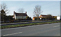
1
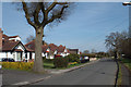
Bungalows, north side of Barkers Lane, Inkford
Image: © Robin Stott
Taken: 29 Mar 2014
0.01 miles
2
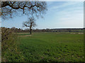
The grass is growing at Inkford
The lonesome oak is a sign that a field boundary has been removed; it enclosed a long narrow triangle near the viewpoint, Barkers Lane.
Image: © Robin Stott
Taken: 29 Mar 2014
0.06 miles
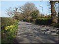
3
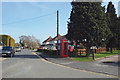
West end of Barkers Lane, Inkford
Inkford is a pocket of suburbia just off the A435 Alcester Road, a fast dual carriageway behind the camera. The postbox is number B47 63.
Image: © Robin Stott
Taken: 29 Mar 2014
0.09 miles
4
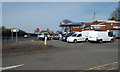
MOT testing and servicing garage, Inkford
At the corner of Barkers Lane, off to the right, and the A435 Alcester Road, left.
Image: © Robin Stott
Taken: 29 Mar 2014
0.10 miles
5
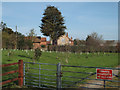
Brook Priory Farm, Inkford
Seen from the footway by the southbound A435 Alcester Road.
Image: © Robin Stott
Taken: 29 Mar 2014
0.12 miles
7
Northeast on Barkers Lane, Inkford
Rooftops reveal the patchy ribbon development along Barkers Lane. It leads to Tanner's Green – the names evoke past rural industry in the Arden woods.
Image: © Robin Stott
Taken: 29 Mar 2014
0.15 miles
8
Lower Inkford Farm and Inkford Court across the A435 Alcester Road
Image: © Robin Stott
Taken: 29 Mar 2014
0.20 miles
9
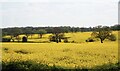
Across the Cole Valley
The River Cole marks the border between Warwickshire and Worcestershire
Image: © planetearthisblue
Taken: 21 Apr 2022
0.22 miles
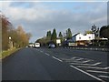
10
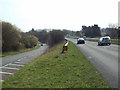
Southbound A435 Alcester Road and slip road south of Inkford
The slip road leads to a pub, the Horse and Jockey; a turning under the A435 leads to Watery Lane and Hillcrest Park, a residential caravan site.
Image: © Robin Stott
Taken: 29 Mar 2014
0.24 miles